Most folks recognize that things do change, bit by bit, but it can be hard to actually pinpoint the major differences without seeing a direct comparison. The “NYC Before and After” Instagram page shares cool pics of how New York City has looked in the past and how it looks now.
Prepare to explore how one of the most famous cities in the world has changed over the years, get comfortable as you scroll through, upvote your favorites and be sure to share your thoughts in the comments section down below.
More info: Instagram
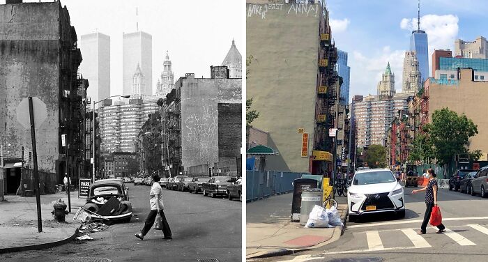
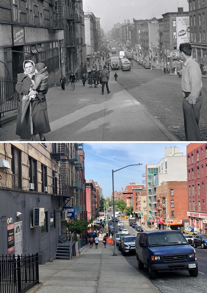
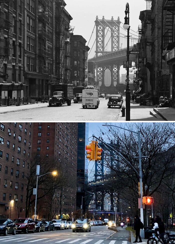
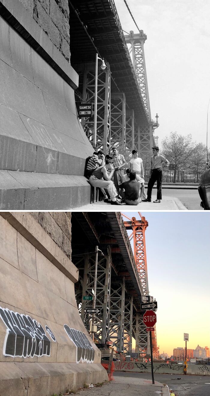
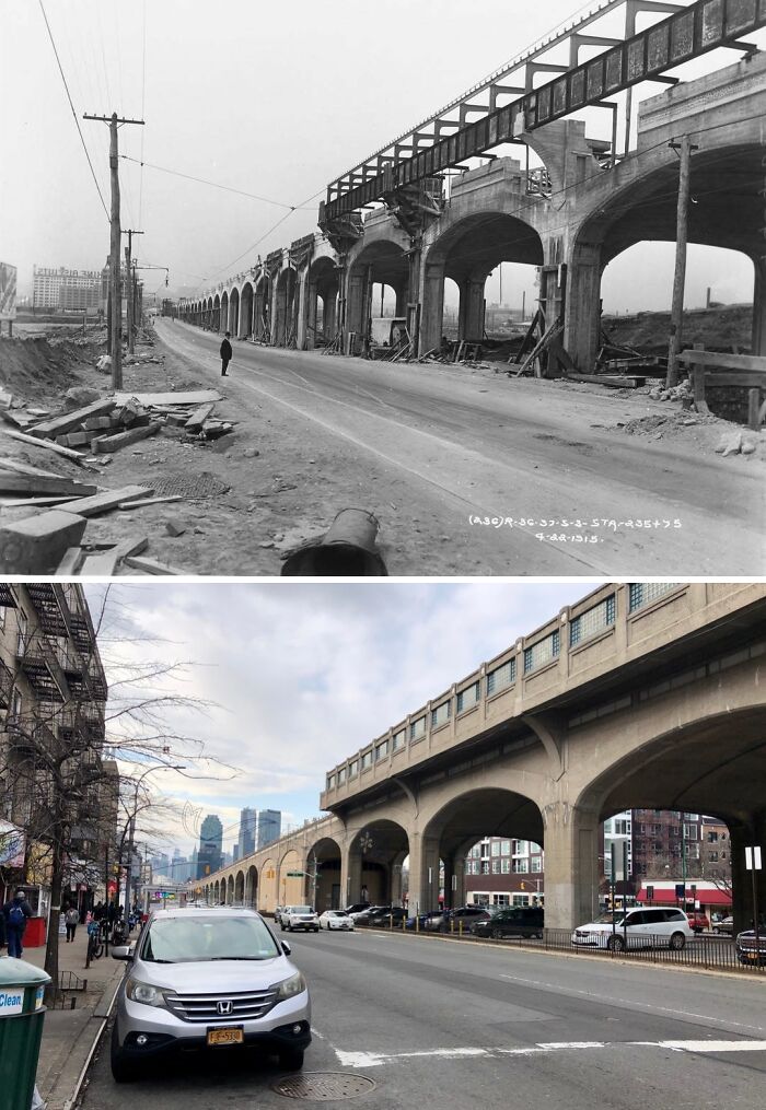
#1 1979 & Today
Looking southwest down Henry St from Market St in Two Bridges, Manhattan.
Off in the distance of the old photo loom one of the most iconic fixtures in the history of New York City’s skyline: the Twin Towers. When the photo was taken, the Twin Towers had only been completed several years earlier with the North Tower (on the right with the antenna) opening in 1972 and the South Tower (on the left) opening in 1973. The Twin Towers held the title of tallest buildings in the world only for a few of years before being surpassed the Chicago’s Sears Tower in 1973. However, the towers would retain the title of tallest in NYC for 3 decades until they met their tragic demise during the 9/11 attacks.
What I find particularly amazing about the old photo is how you can literally see the evolution of NYC’s skyline. Lining both sides of Henry Street are 19th century tenements. Next, the domed building above them is the Manhattan Municipal Building which was completed in 1914. To the left is the Woolworth Building which, when completed in 1913, was the tallest building in the world. And now, 66 years later, the Woolworth Building finds itself completely dwarfed by the massive Twin Towers. At present, the scene remains virtually unchanged save for the for the clear absence of the Twin Towers. Today, rising above the new WTC site, One World Trade Center holds the title of tallest in NYC, the U.S, the Western Hemisphere, and 5th-tallest in the world.
This post is dedicated to the 2,977 victims, their loved ones, the first responders, and everyone else affected on and in the aftermath of the most tragic day in our nation’s modern-day history: September 11, 2001. Never forget.
© Photo: nyc.beforeandafter
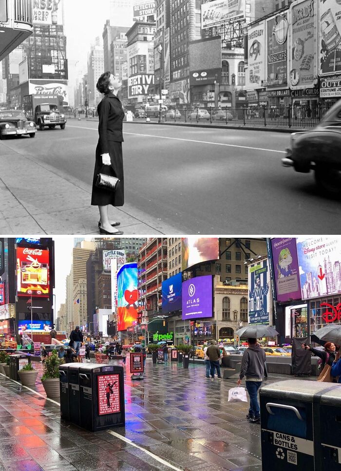
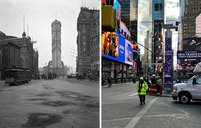
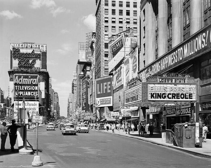
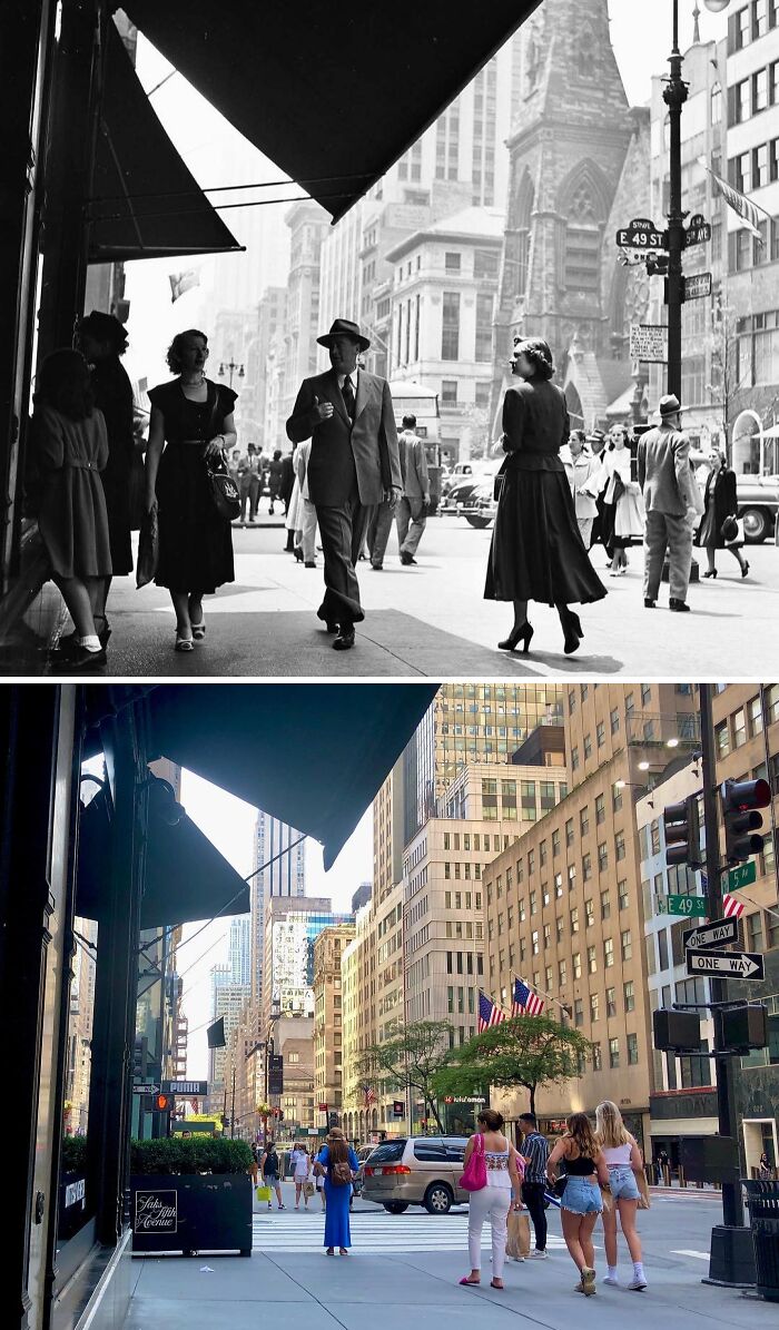
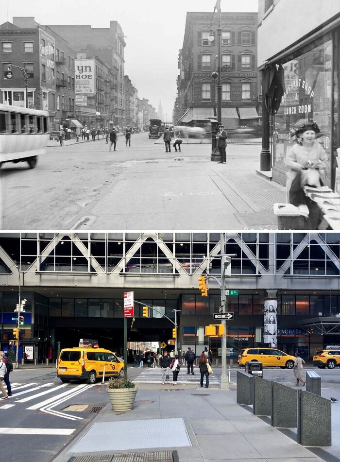
#2 1951 & Today
Looking northeast on Broadway & 7th Ave from W 45th St in Times Square, Manhattan.
.
The principal subject featured in the old photo is the lovely and iconic actress, Audrey Hepburn, who is gazing up the numerous Times Square signs and advertisements. Around the time that the photo was taken, Hepburn was in New York to play the title part of Gigi on the Broadway show of the same name. “Gigi” would run for over 6 months from November 24th, 1951 to May 31, 1952 at the now-demolished Fulton Theatre on 46th Street. Hepburn would go on to break into the motion picture industry not long afterward and would achieve stardom in Hollywood before returning to New York in 1961 to play the character of Holly Golightly in the hit film “Breakfast at Tiffany’s”.
© Photo: nyc.beforeandafter
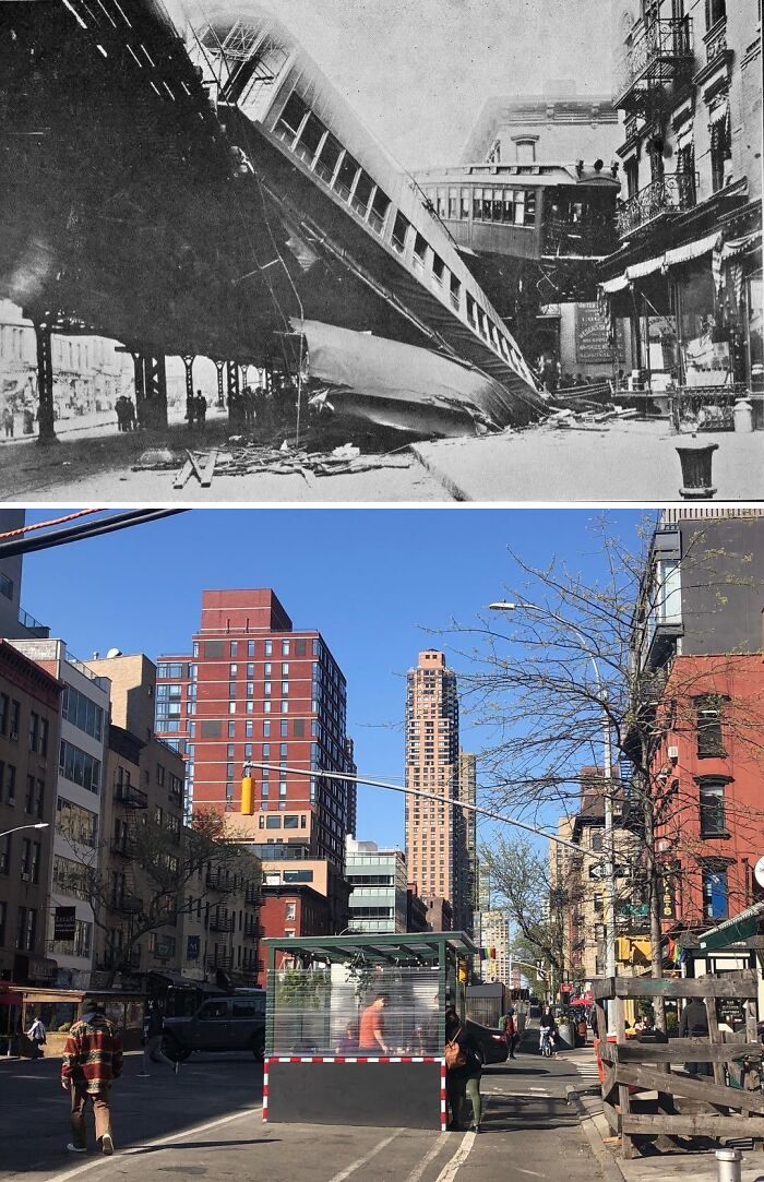
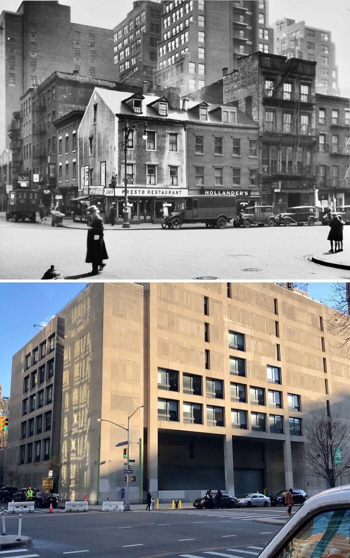
#3 1905 & Today
Looking north on 9th Ave toward W 53rd St in Hell’s Kitchen, Manhattan.
.
The old photo shows the aftermath of the worst elevated train disaster in NYC’s history. The IRT Ninth Avenue elevated line opened in the late 1870s and ran from South Ferry up to 155th Street. The sharp curve seen in the old photo was a spur that ran along W 53rd St & allowed trains to connect the IRT Sixth Avenue El to the east.
On Sep. 11, 1905, during the morning rush-hour, a southbound 9th Ave El was mistakenly switched onto the curve by a switchman. The tight curve had a maximum speed limit of 9 mph, but the motorman failed to notice a signal stating the train’s route had been switched and so the train entered the curve at 25 mph. The lead car cleared the curve but the 2nd derailed and fell onto the street below. The 3rd car came to hang off the edge of the trestle in front of the apartment building to the right, with some passengers even climbing out onto the fire escape after the accident.
In the aftermath, the switchman, Cornelius Jackson, & motorman, Paul Kelly, were found guilty of 2nd-degree manslaughter. Kelly actually escaped the city after the accident and was found and arrested in San Francisco 2 years later. Jackson served 5 years in prison and Kelly served 2 and a half years. In 1909, Kelly & another inmate escaped Sing-Sing prison up the Hudson River but were recaptured shortly afterward. The 9th Ave El would continue operating until 1940, when the line south of 145th Street was closed and demolished.
© Photo: nyc.beforeandafter
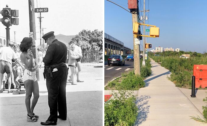
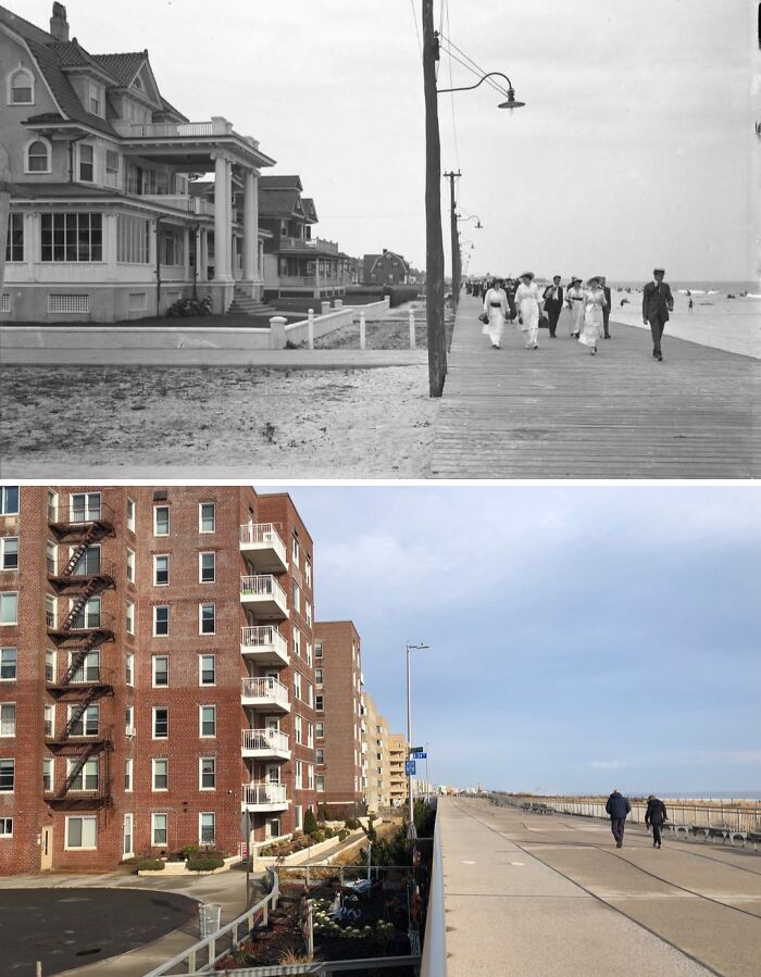
#4 1946 & Today
Looking east on Edgemere Ave at Beach 44th St in Edgemere, Queens.
There’s still time for some fun in the sun before the summer’s out, and nowadays you won’t even have to worry about the swimsuit police. Up until around the early 1960’s most places used to enforce strict sets of laws which dictated what was and was not appropriate for people to wear on public beaches. Anyone deemed “indecently dressed” could expect to receive a fine or even face arrest in some cases. The old photo of today’s post shows a woman receiving such a fine from a police officer. Note the sympathetic smile the woman in the background seems to be giving to her ticketed counterpart 😅
Men were not safe from swimsuit police either. Simply being shirtless was enough to warrant being fined. Ultimately, the laws concerning beach attire were gradually relaxed over the years and or became unenforced.
© Photo: nyc.beforeandafter
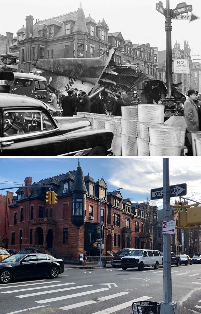
#5 1960 & Today
Looking south at the intersection of 7th Ave & Sterling Pl in Park Slope, Brooklyn.
On Dec. 16, 1960, the deadliest aviation disaster in the world up to that point occurred over the skies of New York City as United Airlines (UA) Flight 826 and Trans World Airlines (TWA) Flight 266 collided in midair over Staten Island. UA Flight 826 was a DC-8 plane bound for Idlewild Airport (now JFK Airport) while TWA Flight 266 was a Lockheed Constellation bound for LaGuardia Airport. The TWA flight went down almost instantly after the collision and crashed in Miller Field on Staten Island. UA Flight 826 lost an engine and part of its right-wing in the collision but remained airborne before ultimately going down in Park Slope a few minutes after 10:30 AM.
The crash produced a large explosion that shook through the neighborhood and scattered wreckage in all directions, as well as setting fire to several brownstone buildings, a church, and numerous businesses. Remarkably, there was initially 1 survivor from the flight discovered at the crash site; Stephen Baltz, an 11-year old boy from Illinois. Baltz was thrown from the plane upon impact and landed in a snow pile. Despite being rushed to the hospital, Stephen sadly passed away the following day, bringing the total toll from the disaster to 134. The cause of the collision was later determined to be that the United flight flew beyond it’s allocated airspace designated by air traffic control.
© Photo: nyc.beforeandafter
#6 1932 & Today
Looking SE at the intersection of 8th Ave & W 28th St in Chelsea, Manhattan.
.
It seems almost unfathomable that both pictures show the same intersection, but alas, it is so. Many of the numerous buildings seen in the 1930’s were demolished in the mid-1960’s to make way for the massive campus of the Fashion Institute of Technology (FIT). Designed in a brutalist style by the architectural firm of De Young, Moscowitz & Rosenberg, the building seen in the present-day photo is the David Dubinsky Student Center and was completed in 1977.
© Photo: nyc.beforeandafter
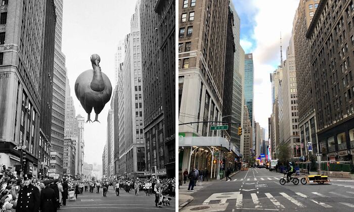
#7 1955 & Today
Looking north on Broadway toward W 37th St in the Garment District, Manhattan.
The old photo shows the 31st annual Macy’s Thanksgiving Day Parade back when the parade route went down Broadway toward Macy’s flagship store at 34th Street. Since 2009, the parade’s route no longer runs down Broadway but instead reaches Macy’s via 6th Ave. The first parade kicked off in the midst of the Roaring Twenties in 1924 and is tied with Detroit’s as the oldest annual Thanksgiving parade in the nation.
The idea of a parade was mainly intended as publicity for Macy’s flagship store, the world’s largest store which had only just opened in 1922. The inaugural parade’s route started way uptown at Convent Ave & West 145th St and ran for 6 miles down to Macy’s on 34th St. Over 250,000 people turned out to see the grand spectacle which culminated with Santa Claus climbing atop a marquee above Macy’s store’s entrance and taking his place on a throne where he was crowned “King of the Kiddies”. So successful and popular the parade turned out to be that Macy’s announced the following morning that they would conduct another parade the following Thanksgiving, and thus, a New York tradition was born.
1927 was the first year in which the parade featured the presence of the giant inflatable balloons that have since become an iconic staple of the annual parade tradition. And though the parade was suspended from 1942-44 due to shortages of rubber and helium during World War II, since then, the parade has continued to be an annual event, even taking place in 2020 albeit significantly scaled back.
© Photo: nyc.beforeandafter
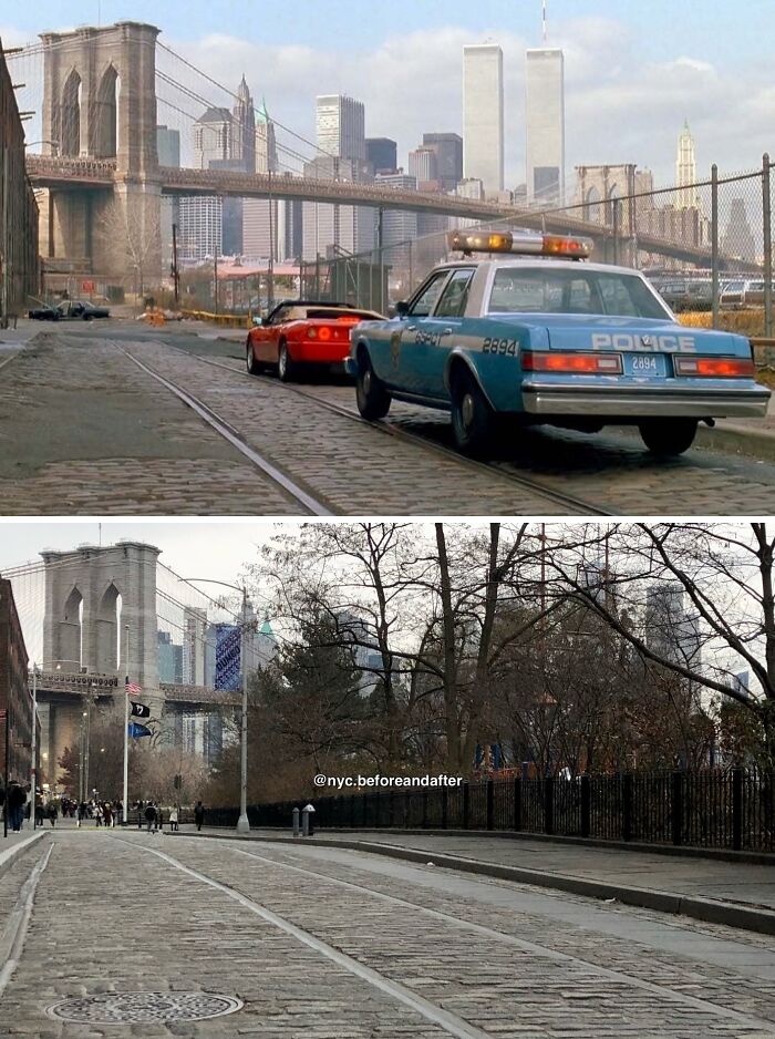
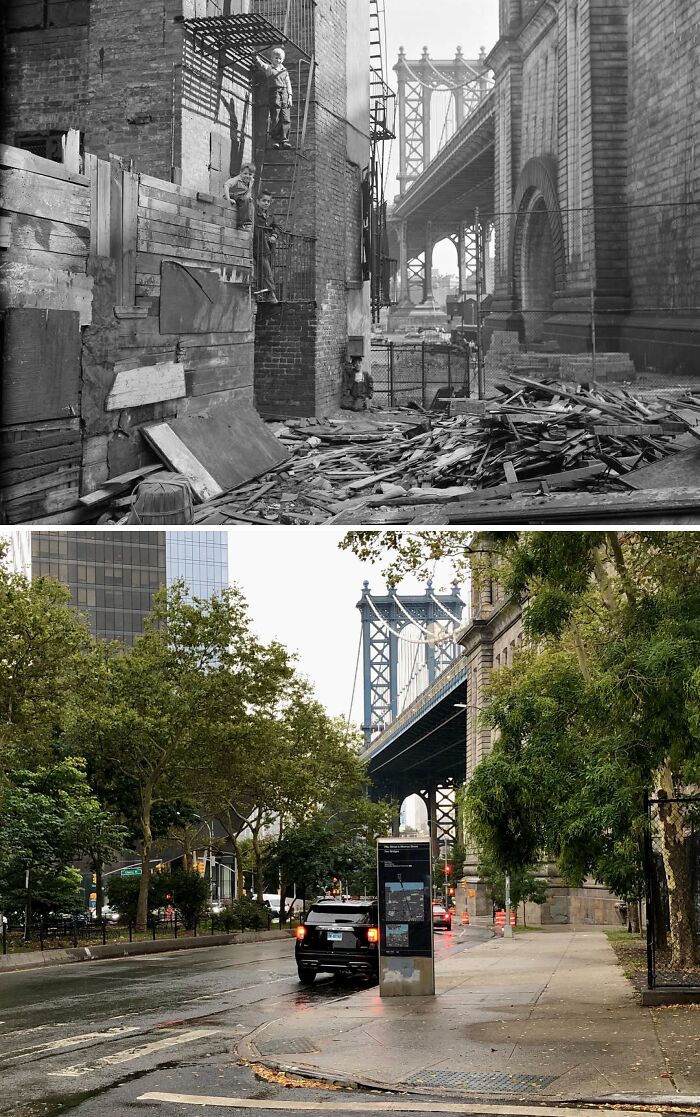
#8 1992 & Today
Looking west on Plymouth St from Washington St in DUMBO, Brooklyn.
The old photo is a still taken from the 1992 Martin Brest film “Scent of a Woman” starring Al Pacino and Chris O’Donnell. In the scene, the characters of Lieutenant Colonel Frank Slade and Charlie Simms are pulled over by a cop after a memorably thrilling sequence in which Pacino’s character—who is blind—test drives a 1989 Ferrari Mondial T Cabriolet through the streets of DUMBO. Like many films and tv shows set in New York prior to fateful September in 2001, the Twin Towers were an essential part of the backdrop, boldly proclaiming to the viewer “This is New York”. I think it’s fair to say that cinematographer Donald E. Thorin did the Towers justice in this shot.
The Twin Towers are no longer here, of course, and neither is the parking lot on the right-hand side. Today, that area forms part of the 85-acre Brooklyn Bridge Park. The new One World Trade Center isn’t visible from this spot due to the trees, but head a block down the street and you’ll be treated to a commanding view of it, the Brooklyn Bridge and the rest of the Lower Manhattan skyline.
© Photo: nyc.beforeandafter
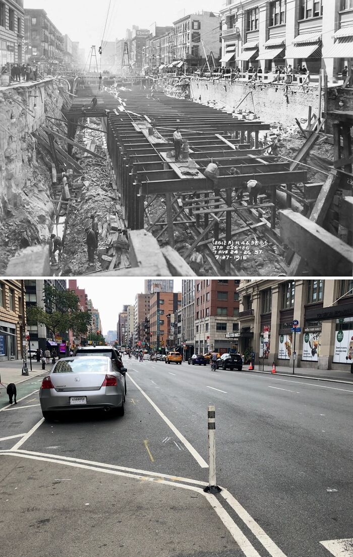
#9 1916 & Today
Looking south on 7th Ave from W 26th St in Chelsea, Manhattan.
On this day, 118 years ago, the New York City subway system first opened to the public. The first subway line contained just 28 stations and ran from City Hall north to 145th Street. Today, the subway system contains 24 routes and 3 shuttles that cover a whopping 472 stations spread across 4 of the 5 boroughs. With millions depending on it every day, the subway is truly the critical engine that drives New York and it is difficult to imagine the city having developed into the metropolis that it is today without this vital piece of infrastructure.
Of course, the subway didn’t just spring into existence out of nowhere; it had to be built. The old photo above shows 7th Avenue completely dug out and several men hard at work down on the construction of the IRT Broadway-Seventh Avenue Line. The primary form of construction during the subway’s early years was the so-called cut-and-cover method that would involve hundreds of men having to dig up a roadway, building the system and stations, and finally roofing it all and restoring the roadway up above.
Early subway construction was certainly a dangerous occupation and most workers were unskilled immigrants who received very low wages, with many undoubtedly being injured in accidents over the decades. So, on the subway’s 118th birthday, taking a moment to reflect and appreciate the back-breaking work and lives that so many perservering men gave in order for millions today of the nation’s largest city to be able to get from Point A to Point B.
© Photo: nyc.beforeandafter
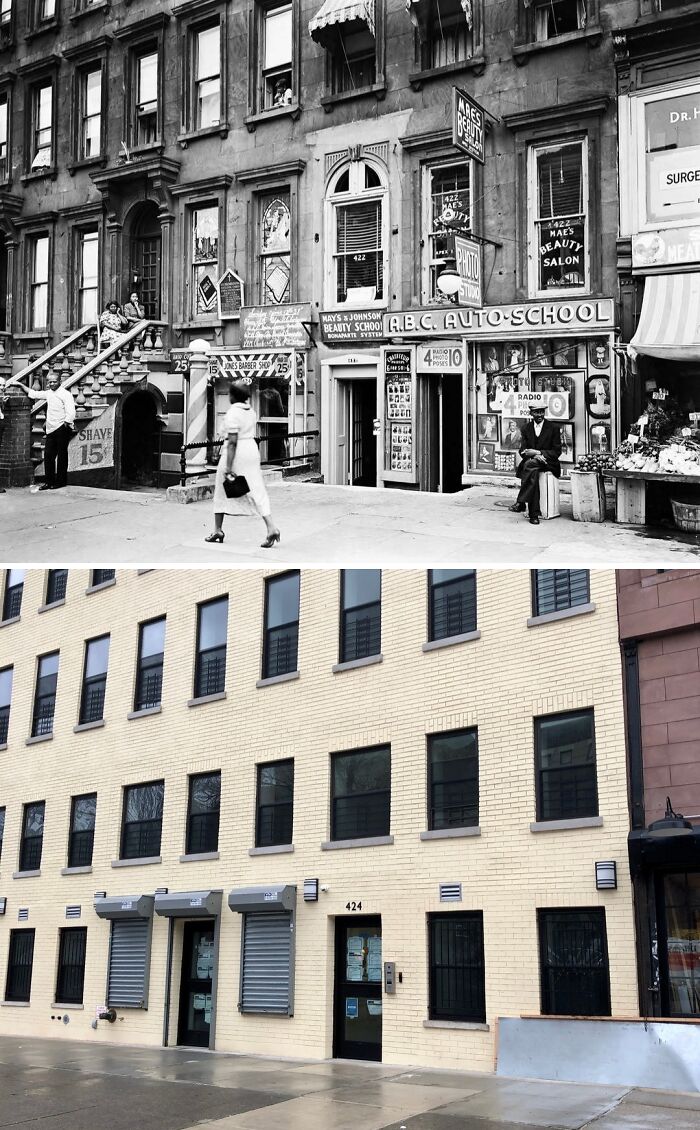
#10 1938 & Today
The east side of Lenox Ave from W 131st St in Harlem, Manhattan.
.
Although the buildings in both images are the same, the charm, liveliness, and personality that was present in the 1930’s has since given way to a bland and stale scene. The buildings have sadly undergone many alterations such as covering up the lovely brownstone exteriors and removing the iconic stoops.
.
However, to me, the biggest loss of all is that of the multiple local businesses that have since disappeared. It was locally-owned businesses such as that that once dotted the streets and gave life to not just Harlem, but to the whole of New York City. From left to right the old photo shows a barber shop, a Pentecostal church, a beauty school, an auto school, a photo studio, a beauty salon, a doctor’s office, and a grocery store. Today there is nothing.
© Photo: nyc.beforeandafter
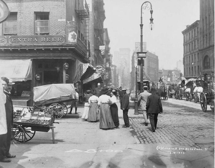
#11 1907 & Today
Looking west on the south side of Canal St from Mott St in Chinatown, Manhattan.
.
What appears to be the Star of David on the corner building is actually most likely the logo for the George Ehert’s Brewery. Regardless, for a long time there existed significant Jewish community in the area, mostly consisting of immigrants recently arrived from Europe. Over the course of the 20th century however, most of the Jewish population has moved away. Presently, save for Little Italy across Canal Street to the north, the area is now predominantly Chinese.
.
Also, note how even in 1907 Canal Street was congested with traffic, in this case horse-drawn vehicles. This is even more remarkable given the fact that photo was taken 2 years before the opening of the nearby Manhattan Bridge to the east. Canal Street today owes much of its congestion to the bridge and Holland Tunnel due to it serving as a connector between two. Seeing how busy the street was before the bridge even opened, one can only imagine the traffic jams that would ensue in a couple of years.
© Photo: nyc.beforeandafter
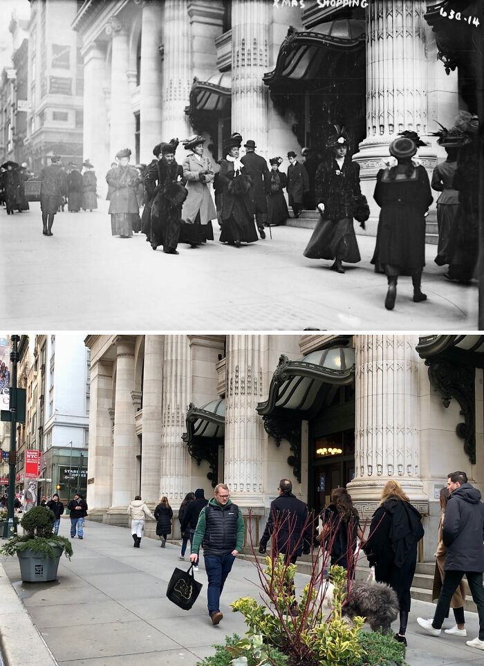
#12 1900’s – 1910’s & Today
Looking north on the east side of 5th Ave from E 34th St in Midtown Manhattan.
.
Hurry, hurry, hurry! There’s still time to get your Christmas shopping done! Though unlike the people seen in the old photo you can’t get that shopping done at the B. Altman & Company department store given that it no longer exists. The store was founded on Manhattan’s Lower East Side in 1865 by Benjamin Altman. Largely designed in a Renaissance Revival style, the company’s flagship store on Fifth Avenue opened in 1906 and takes up an entire city block from between 34th and 35th Streets and 5th and Madison Avenues. Altman’s would operate out of the building for over 8 decades before the company filed for bankruptcy in 1989 and ceased operations.
.
Since its glory days as a department store, the building today has been repurposed and primarily houses the CUNY Graduate Center. Did you ever visit Altman’s on 5th Avenue back in the day? Feel free to let me know in the comments section down below! And if you do decide to get your last-minute Christmas shopping done, please bundle up and stay warm! It’s cold outside! 😊
© Photo: nyc.beforeandafter
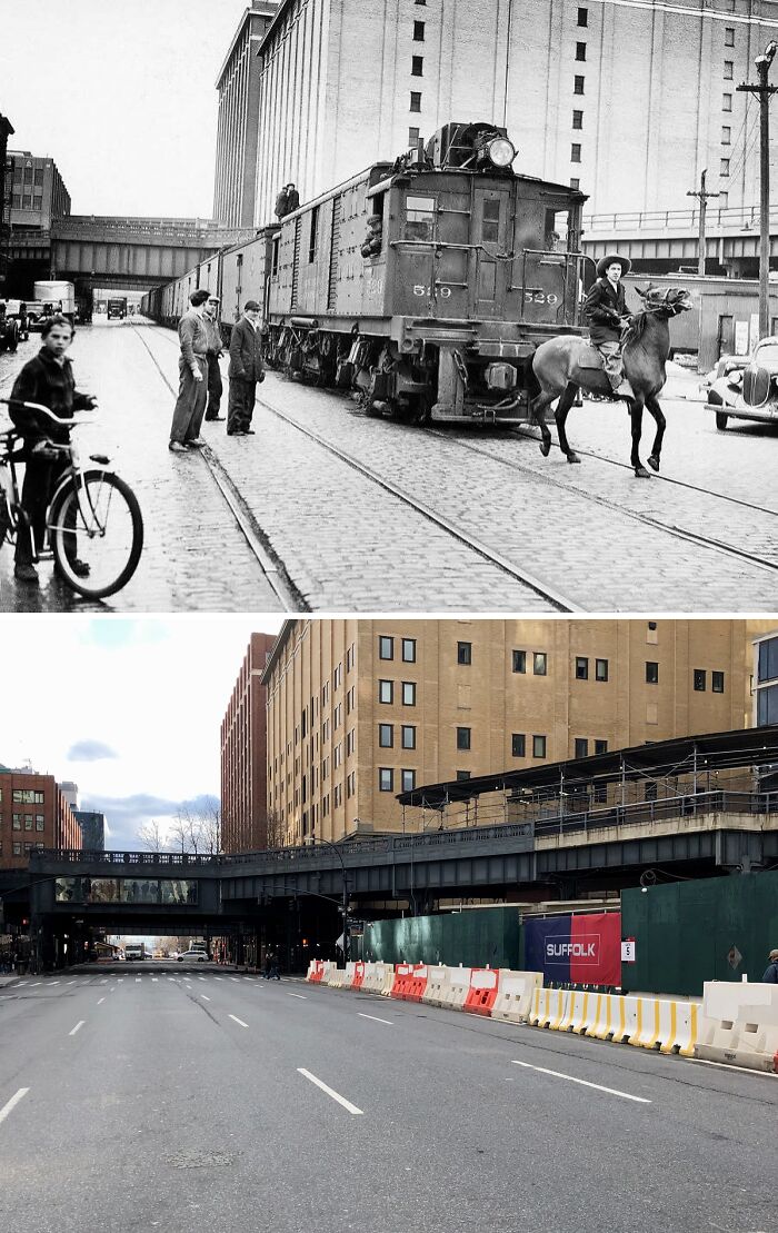
#13 1941 & Today
Looking south down 10th Ave from W 18th St in Chelsea, Manhattan.
A ghost. That is the term that some by the mid-20th century might’ve used to describe the proverbial American cowboy; a character which by then belonged to the history books & to eternity in the man-made purgatory that was the “Western” film genre. However, unbeknownst to many, the cowboy actually continued to live on for several more decades after the conquest of the west in an entirely unexpected setting: New York’s West Side.
The “West Side Cowboy” came about as a result of the New York Central Railroad building freight train tracks running up and down 10th & 11th Avenues in 1847. Unlike the elevated passenger trains of later decades, these freight trains actually ran at street-level with no barriers or dividers to protect vehicles and pedestrians from crossing paths with oncoming trains. As a result, the railroad would hire “cowboys” whose job it would be to ride on horseback ahead of the moving trains while waving flags to signal that a train was approaching. However, even with the cowboys, hundreds of accidents would occur over the decades.
Led by Robert Moses, the 1929 West Side Improvement Project sought to eliminate the street-level railroad crossings by constructing an elevated viaduct for freight trains to safely run on. The viaduct debuted in 1934 but some trains would continue running on 10th Ave for 7 more years. The old photo in this post was taken March 29, 1941, and shows 21-year-old George Hayde and his horse Cyclone: the last “West Side Cowboy” leading the last train. Today, that 1934 viaduct is the iconic High Line park.
© Photo: nyc.beforeandafter
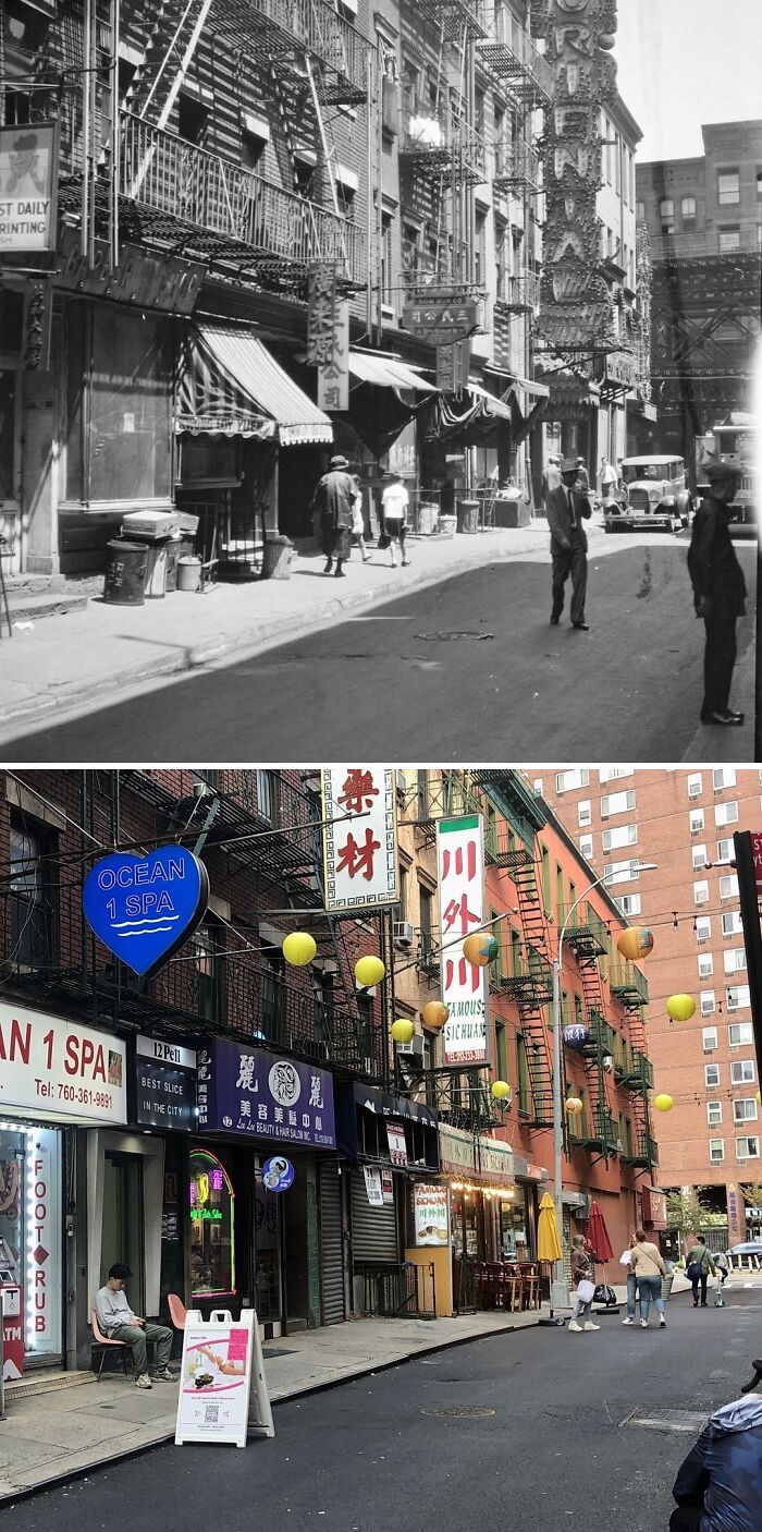
#14 1930’s Or 40’s & Today
Looking east on Pell St from Doyers St in Chinatown, Manhattan.
.
It’s refreshing to see that most of the buildings seen in the old photo still stand today and have remain largely unaltered. Note the elevated structure seen on the right side of the old photo and the buildings behind it that have since been demolished. The structure carried IRT Second Avenue Line trains until 1942 and IRT Third Avenue Line trains until 1955 before being demolished. The aforementioned buildings were razed to make way for the present 44-story Confucius Plaza apartments complex.
© Photo: nyc.beforeandafter
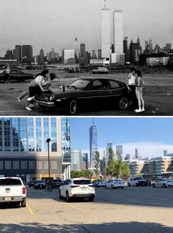
#15 1983 & Today
Looking east toward the Lower Manhattan skyline from Hudson St and Second St in Jersey City, New Jersey.
.
This cool retro photo shows 2 unidentified couples, each sharing a romantic moment, on a derelict pier with the Twin Towers looming across the Hudson River. When this photo was taken, the Twin Towers had only been fully completed some 10 years earlier. Despite that short amount of time, it did not take long for the two massive 110-story marvels of engineering to cement their places as integral icons of New York City; a city desperate to rejuvenate itself after having fallen on some pretty hard times. The Twin Towers would reign supreme over the New York skyline for just under 3 decades before their tragic destruction during the 9/11 attacks in 2001.
.
Today, the new One World Trade Center stands just north of where the North Tower once stood and holds the title of of the tallest building in New York, the United States, the Western Hemisphere, and 5th-tallest in the world. The Jersey City waterfront has seen much change since the 80’s. During the 90’s, this area underwent large-scale revitalization and is now known as Exchange Place and contains a concentration of high rise office and residential buildings.
.
This post is dedicated to the 2,977 victims, their loved ones, the first responders, and everyone else affected on and in the aftermath of one of the most tragic days in modern history: September 11, 2001. Never forget.
© Photo: nyc.beforeandafter
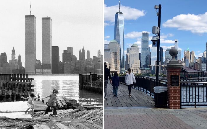
#16 1980 & Today
The Lower Manhattan skyline from across the Hudson River in Jersey City, New Jersey.
The old photo shows 2 girls walking along the derelict Jersey City waterfront with New York’s imposing Twin Towers looming across the Hudson. The Twin Towers were not even 10 years old when the photo was taken and the entire World Trade Center complex had still yet to be fully completed as seen by the construction of 3 World Trade Center (later known as the Marriott World Trade Center) between the two towers. The separate World Financial Center closer to the shoreline where the Winter Garden Atrium is located had also yet to be built, allowing for a fully unobstructed view of the Twin Towers from New Jersey.
Construction on the World Trade Center began in the late 1960’s on the site of the former neighborhood of Radio Row. The North Tower was completed in 1972 & the South Tower in 1973. Each tower stood at 110 stories tall & were the tallest buildings in the city; 1 WTC being the taller of the two as a result of its antenna spire. Combined, the towers provided nearly 10 million sq ft of office space for about 35,000 people. The WTC complex was a city within a city. During the 3 decades that they stood, the Twin Towers became an integral part of New York’s cityscape and it was hard to find a tv show or movie set in New York from that time without the Twin Towers featured prominently in at least one scene. It was simply impossible to imagine New York without them…
Today, the new One World Trade Center, completed in 2014, stands just north of the former site of the North Tower & holds the title of the tallest building in the city and the Western Hemisphere.
This post is dedicated to the 2,977 victims, their loved ones, the first responders, and everyone affected on or by Sep. 11, 2001. Never forget
© Photo: nyc.beforeandafter
#17 1935 & Today
Looking south on W 12th St from Bowery St in Coney Island, Brooklyn.
.
The only thing that is present in both photos is the iconic Wonder Wheel. The NYC Landmark was designed by Charles Hermann and originally opened on Memorial Day, 1920. The Wonder Wheel stands at 150 ft tall – roughly equivalent to a 15-story building – weighs over 200 tons and has 24 cars, of which 16 are swinging and 8 are stationary. For 6 decades the ride was owned operated by Hermann’s son, Fred, until it was sold to Denos D. Vourderis in 1983. The Vourdeis family restored the wheel and today it is the star attraction of Deno’s Wonder Wheel Amusement Park.
.
In the old photo can also be seen an attraction known as “Scoota Boats” (an electric boat ride) and a ride known as the Virginia Reel. Both most likely lasted into the 1960’s before they were demolished. The roller coaster seen in the present-day photo is new, having just opened this year. It is known as The Phoenix and also forms part of Deno’s Wonder Wheel Amusement Park.
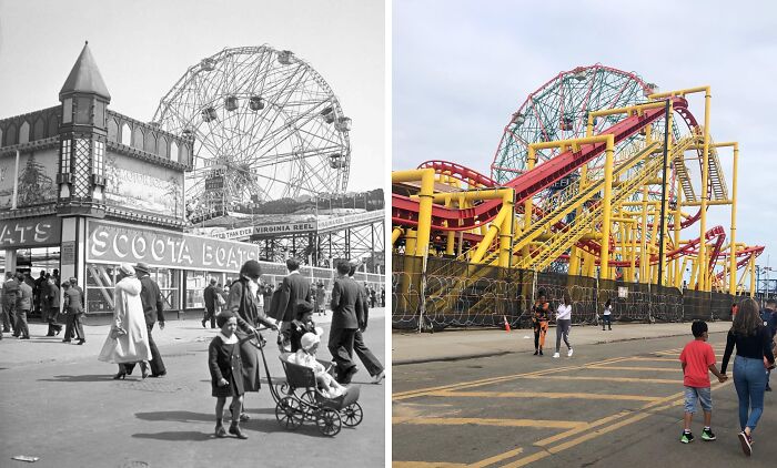
© Photo: nyc.beforeandafter
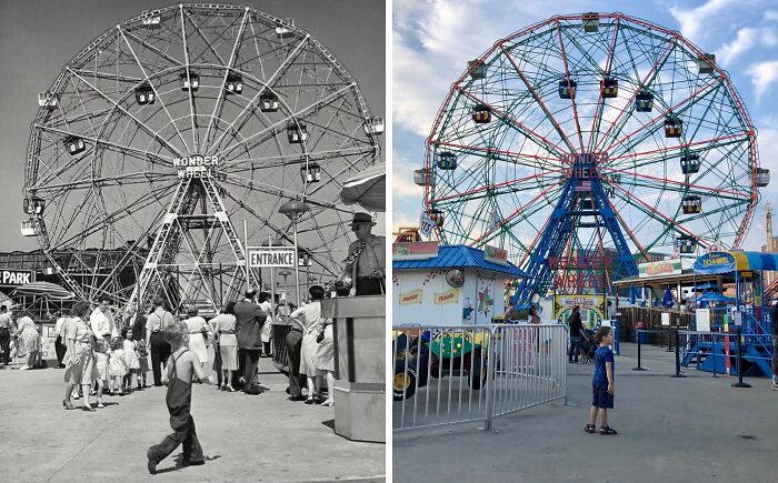
#18 1950’s & Today
Looking north toward the Wonder Wheel at Coney Island, Brooklyn.
.
Built in 1920, the iconic Wonder Wheel is a Coney Island staple, and it is, in fact, Coney Island’s oldest continuously operated attraction. The Wheel was the brainchild of Charles Hermann, a Romanian immigrant with a passion for engineering as well as amusement park rides. Hermann envisioned the Wonder Wheel as combination of scenery and thrills. To achieve this, the steel Wheel was built to rise to a height of 150 ft (45.72 m) above the ground, roughly equivalent to the height of a 15-story building, which offers the riders incredible unobstructed views of Brooklyn and the distant Manhattan skyline. And for maximum thrills, of the Wheel’s 24 gondola cars, 8 are stationary whilist the remaining 16 swing in and out on a set of snaking tracks. For 6 decades, the ride was owned operated by Hermann’s son, Fred, until it was sold to Denos D. Vourderis in 1983. The Vourdeis family restored the Wheel and today it is the star attraction of Deno’s Wonder Wheel Amusement Park and continues to wow and thrill New Yorkers and visitors alike as it has done for the past 102 years. The Wonder Wheel was designated a New York City Landmark in 1989.
© Photo: nyc.beforeandafter
#19 1950’s & Today
© Photo: nyc.beforeandafter
#20 1906 & Today:
Looking south on Broadway & 7th Avenue from W 46th St in Times Square, Manhattan.
Times Square—the place where generations of New Yorkers and tourists alike have gathered to usher in the New Year as the iconic glittering ball makes its descent atop the roof of One Times Square. When the old photo was taken, however, there was no annual ball drop yet. No. That wouldn’t take place until the following year in 1907 when New York Times owner Adolph Ochs, in a bid to outdo his previous practice of a fireworks display from atop the roof of the Times headquarters, decided to initiate the now-world famous ball drop. Ever since, the ball drop has taken place each year save during 1942 and 1943 as a result of World War II blackout restrictions.
And so we bid farewell to 2025. It’s hard to believe we’re already more than halfway through this most hectic decade that is the 2020’s. I’m hoping I’ll be able to announce something momentous involving this page sometime next year, so stay tuned for that! 2026 is also shaping up to be a big year for the city as well with the World Cup (as well as the coveted final) coming in summer. Also, for the first time-ever, there will actually be a SECOND BALL DROP! Yes, you heard that right! In honor of America’s 250th birthday, Times Square will host a special ball drop at midnight on July 4th, 2026 to commemorate the ratifying of the Declaration of Independence.
From myself to wherever you may be, I wish all of you a happy and prosperous 2026!
© Photo: nyc.beforeandafter
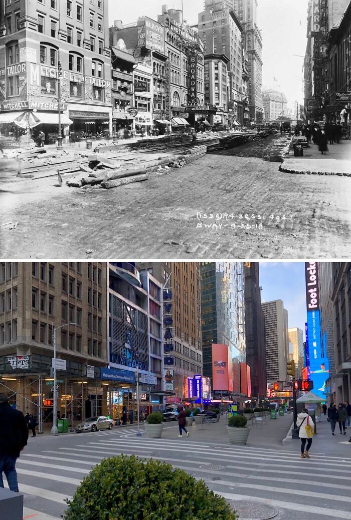
#21 1918 & Today
Looking north at Broadway & W 40th St in Midtown, Manhattan.
.
The old photo shows Broadway when the Theatre District extended farther south of its current boundaries centered around and north of Times Square and 42nd Street. Over the next few decades, this would gradually change as ‘Broadway’ moved north and the area south of 42nd Street became more manufacturing; retail; and commercial-oriented.
.
Also, note the roadwork taking place in the 1918 photo. This was likely the repaving and restoration of Broadway’s road surface after the construction and opening of the underground BMT Broadway Line which had been built using the cut-and-cover method.
© Photo: nyc.beforeandafter
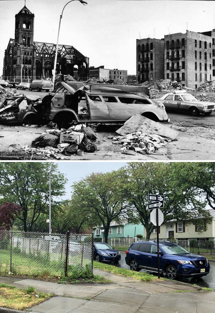
#22 1980 & Today
Looking NE on Seabury Pl from Charlotte St in Crotona Park East, The Bronx.
.
What you are looking at is not some fictional imagining of a post-apocalyptic future but rather the real & horrid reality that was the Bronx during the 1970’s & 80’s. During this time, it was not uncommon to see large sections of, or even entire neighborhoods completely reduced to rubble with large burnt out apartment buildings interspersed among the bleak & desolate landscape.
.
It can be argued that the decline of the Bronx began following WWII. Whilst we tend to look back on this time as being one of nationwide prosperity, this was not necessarily the reality for minorities in America’s cities. In 1955, the Cross Bronx Expressway opened, a project spearheaded by Robert Moses that required the demolition of hundreds of buildings in mostly working-class Black & Puerto Rican neighborhoods, & resulted in the displacement of over 60,000 residents. The end result was entire communities being left physically divided & polluted, which, in turn, caused property values to plummet.
.
By the 1960’s, as quality of life declined, many residents, particularly middle-to-upper class Whites, began to leave the Bronx in favor of the suburbs. By the late 60’s, many landlords & building owners saw little to no point in maintaining their underpopulated apartment buildings, causing them to fall into a state of disrepair. As a result, many chose to purposely burn them in order to collect the insurance money. By the end of the “Decade of Fire”, many areas of the Bronx lay in ruins & it would be many years before some neighborhoods began to recover. This specific zone’s recovery began during the 1980’s & today it’s known as Charlotte Gardens.
© Photo: nyc.beforeandafter
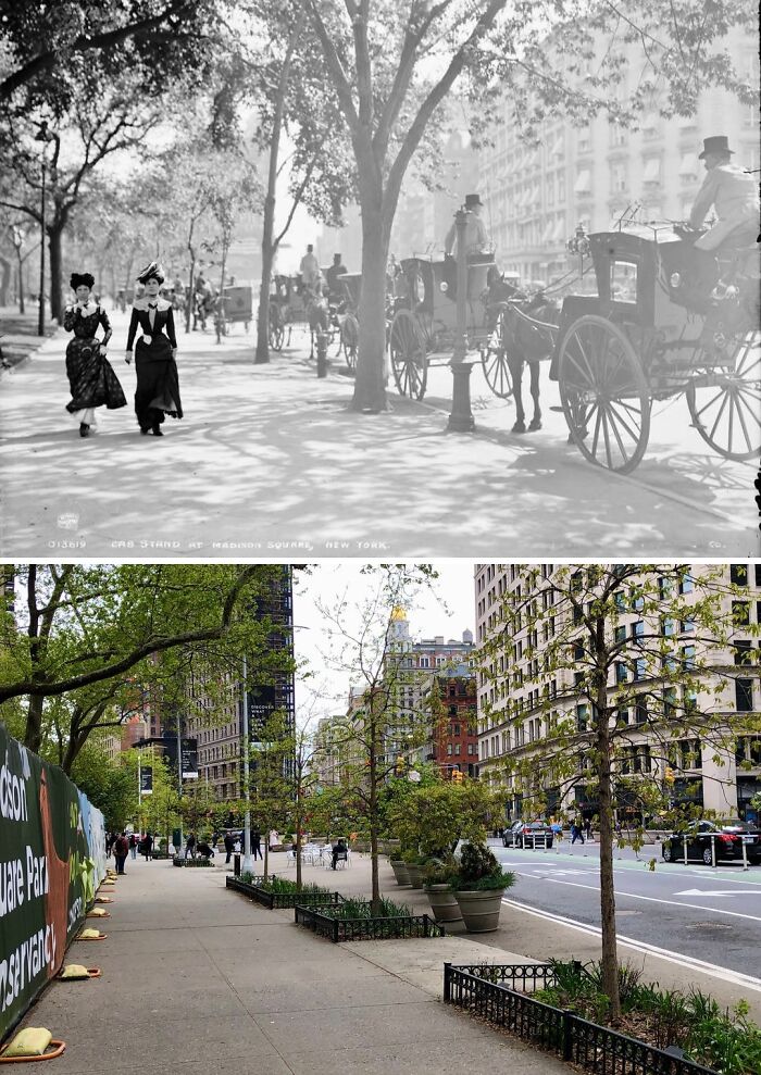
#23 1900 & Today
Looking south on 5th Ave from opposite W 25th St in the Flatiron District, Manhattan.
.
The old photo offers us one of the last glimpses of Gilded Age New York; an age that would soon give way to the Progressive Era during the early years of the 20th century prior to World War I. On left a pair of fashionably-dressed ladies stroll beside Madison Square Park and past a line of horse-drawn cabs waiting to pick up passengers. The iconic Flatiron Building was yet to begin construction and the Fifth Avenue Hotel seen on the right was still standing. The Flatiron Building would rise above the neighborhood in 1902 whilst the hotel would be demolished in 1908 and replaced by the existing building at 200 Fifth Avenue. Also, note how the trees on the right in the old photo appear to have been replaced sometime between then and now.
© Photo: nyc.beforeandafter
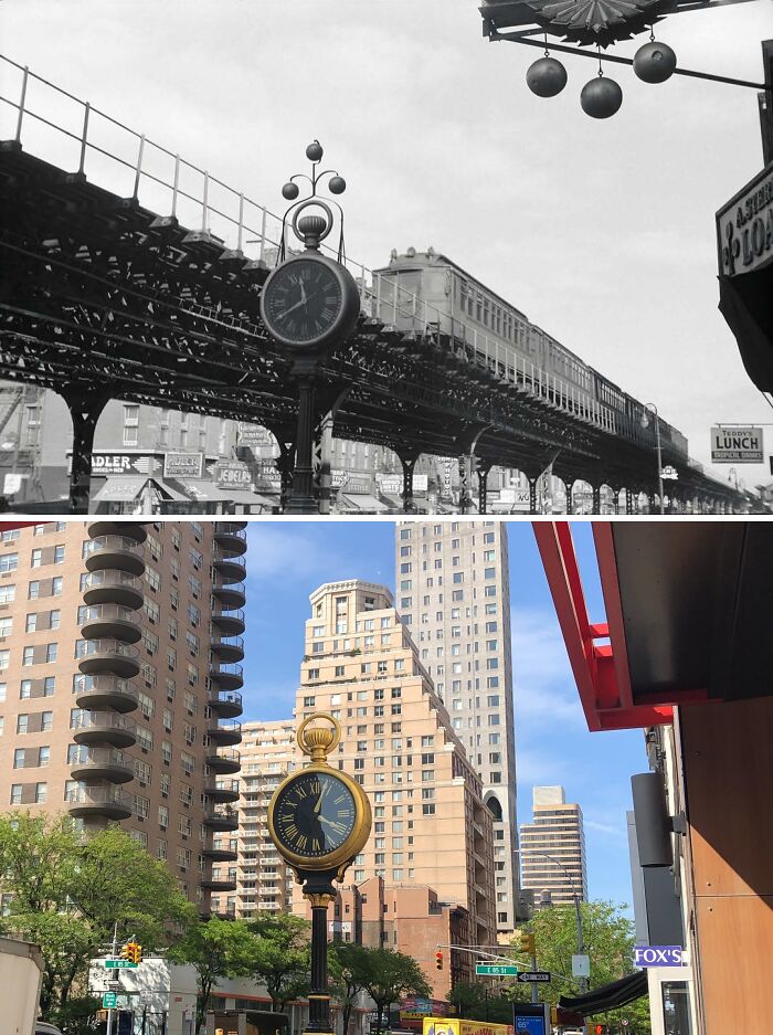
#24 Early 1950’s & Today
Looking north on 3rd Ave toward E 85th St in Yorkville, Manhattan.
.
I admit that when I got to this spot in order to recreate the photo for this post, I was amazed to see that the sidewalk clock seen in the old photo was still standing after all these years! In fact, the clock has actually been around since 1898! Designed to resemble a pocket watch, the clock was originally located on the northwest corner of 3rd Avenue & East 85th Street in front of the jewelry store of Adolph Stern. The clock was moved to its current spot in 1923 in front of a new pawn shop that Stern had opened. In 1981, the Yorkville Sidewalk Clock was designated a NYC Landmark.
.
One thing that has not survived the test of time however, besides the numerous buildings, is the elevated IRT Third Avenue Line. Opened in 1878, at its greatest extent the line ran from South Ferry on the southern tip of Manhattan all the way north to Gun Hill Road in the Bronx. Eventually, by the time of the Great Depression, the el’s had come to be seen in a negative light with many deriding them as loud and dirty antiquated relics of a bygone era which negatively affected property values all along their routes in contrast to the underground subways. One by one, the el’s began to come down and by 1942, following the demolitions of the elevated IRT Sixth, Ninth, and Second Avenue Lines, the Third Avenue El was the last fully elevated line left on the island of Manhattan.The Third Avenue El would live on until 1955 when the line between South Ferry and 149th Street was closed and subsequently demolished.
© Photo: nyc.beforeandafter
#25 1958 & Today
© Photo: nyc.beforeandafter
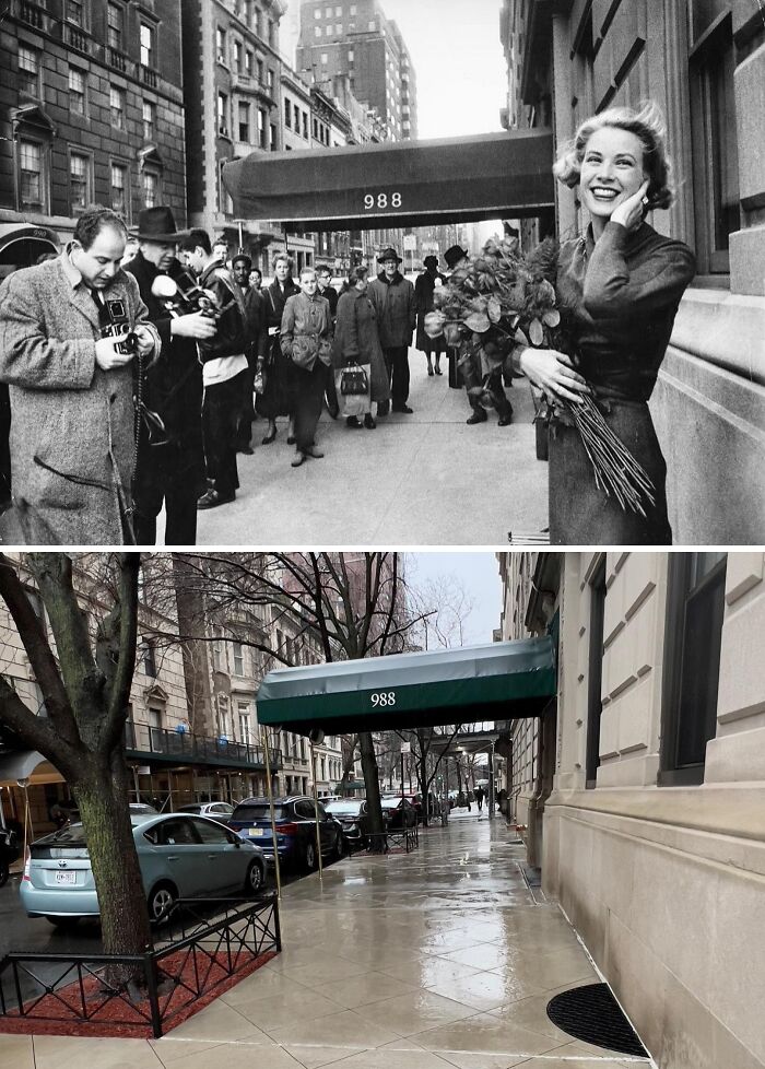
#26 1956 & Today
Looking east on E 80th St from 5th Ave on the Upper East Side, Manhattan.
.
Smiling as radiant as ever in the old photo is actress Grace Kelly outside her New York apartment building at 988 5th Avenue. Just a few weeks after the photo was taken, Ms. Kelly would leave the silver screen and the States for good when she married Rainier III, Prince of Monaco, in one of the most high-profile royal weddings of the 20th century.
.
Grace Kelly’s first major film role was in the 1952 western High Noon where she starred alongside Gary Cooper. Next came 1953’s Mogambo with Clark Gable & Ava Gardner. In 1954, aged 25, Kelly won the Academy Award for Best Actress for her role in the film The Country Girl. However, Kelly is perhaps best well-known as the leading lady & favorite of director Alfred Hitchock’s famous blonde muses during his golden era. Under Hitchock’s direction, Grace Kelly would star in Dial M for Murder (1954), Rear Window (1954), & To Catch a Thief (1955). Her surprise engagement & marriage to the Prince of Monaco (whom she met in 1955) left a void in Hitchcock’s films which he struggled to fill in subsequent years. In an alternate universe, we might’ve seen Grace Kelly star in Vertigo, North by Northwest, & maybe even Psycho!
.
Princess Grace would have three children with Prince Rainier III (including Prince Albert II, the reigning Prince of Monaco) & would be active in various charitable organizations throughout the rest of her life. Tragically, she would lose her life as a result of injuries sustained from a car accident after she suffered a cerebral hemorrhage while at the wheel on Sep. 13, 1982. The princess would die from her injuries the following night at the age of 52. She is buried inside the Cathedral of our Lady Immaculate in Monaco.
© Photo: nyc.beforeandafter
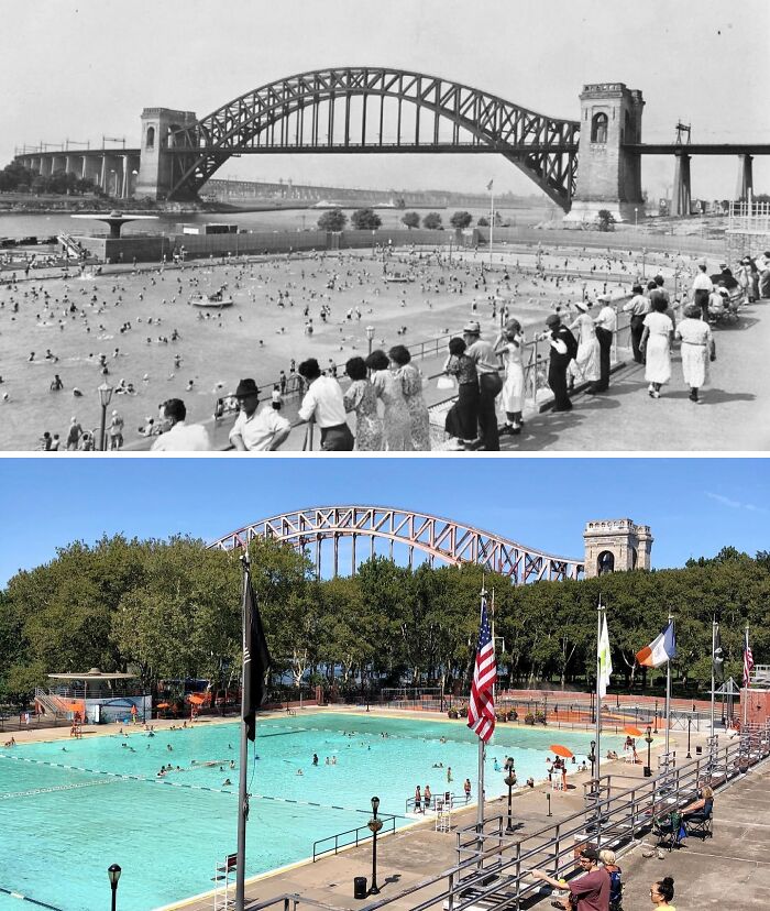
#27 1936 & Today
Looking north toward the Hell Gate Bridge from the Astoria Pool in Astoria, Queens.
.
The old photo was taken during Astoria Pool’s inaugural summer season, having been opened on July 2, 1936. Framed by the Hell Gate Bridge to the north and the Triborough Bridge (off-screen) to the south, the Astoria Pool was 1 of 11 large public swimming pools built in 1936 with funding from the Works Progress Administration. .
The construction of the pool, Astoria Park, and the aforementioned Triborough Bridge were all overseen by-then New York City Parks Commissioner Robert Moses. However controversial his legacy might be today, Astoria Pool is most certainly one of the positive things to come out of his decades-long tenure in New York City urban planning. Featuring lovely Art-Deco design elements, the pool measures in at 330 by 165 feet and is the largest of the 11 WPA pools and was designed to accommodate up to 5,500 bathers at a time!
.
The pool immediately became popular with locals, especially children, who would visit it on a daily basis during the scorching New York summers of an era before air conditioning was widely available. Only 2 days after its opening, the pool would host Olympic Trials for the U.S Swim and Diving Teams ahead of the 1936 Olympics in Berlin. The Trials produced several winners, including gold medal swimmers Jack Medica and Adolph Keifer. The pool would go on to host Olympic Trials again in 1952 and 1964 ahead of the Games in Helsinki and Tokyo respectively. Astoria Pool remains open to this day and was designated a New York City Landmark in 2006.
.
Meanwhile, the 1,017-foot Hell Gate Bridge opened in 1916 as a railroad bridge and connects Queens to Randalls and Wards Islands. The bridge was also the inspiration for the design of the famous Sydney Harbour Bridge in Australia, which opened in 1932.
© Photo: nyc.beforeandafter
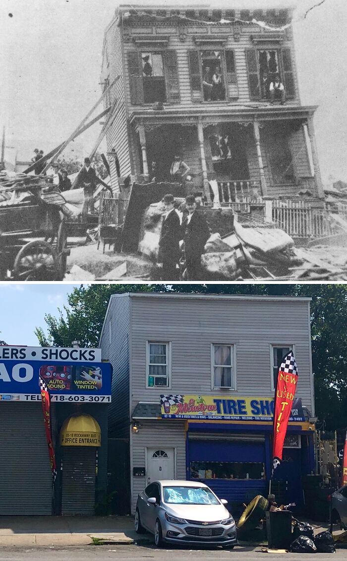
#28 1895 & Today
The south side of Rockaway Blvd from 83rd St in Ozone Park, Queens.
July 13, 1895, was shaping out to be just an ordinary day in the suburb of Woodhaven, Queens (today, this area is part of Ozone Park). Then, at around 4:18 PM, a massive dark funnel-shaped cloud between 200 & 300 yards wide suddenly appeared & came barreling down toward the unsuspecting residents below. It was a tornado.
Upon reaching town, the tornado uprooted trees, [destroyed] livestock, & ripped houses right off their foundations. Numerous buildings had their windows blown in & several people who were caught outdoors were lifted right off the ground and flung through the air. The old photo of today’s post shows a house in the aftermath of the storm. The worst damage occurred at the recently-built PS 59 brick schoolhouse at Rockaway Blvd & 95th Ave with the building left completely destroyed Thankfully, because it was summer, the school was empty at the time of impact. Tragically, the tornado would claim 1 life that day; that of a 16-year-old French girl named Louise Petroquien. Louise had recently married a man who worked at the nearby Lalance & Grosjean Factory on Atlantic Ave. When she saw the tornado approaching, she ran out of her house to warn her mother who was out in the garden when a beam that had been ripped off of the PS 59 schoolhouse flew and struck her in the head. The next day, a 5-year-old boy named Johnny Kolb who’d been rescued from rubble after the tornado also died from his injuries.
Following the tragic storm, thousands of people came from miles around, especially from Manhattan & Brooklyn, to view the devastation. Tornadoes are, of course, a rarity in New York City and are typically associated with Tornado Alley out west, but they can occur anywhere and at any time as the residents of Woodhaven sadly found out.
© Photo: nyc.beforeandafter
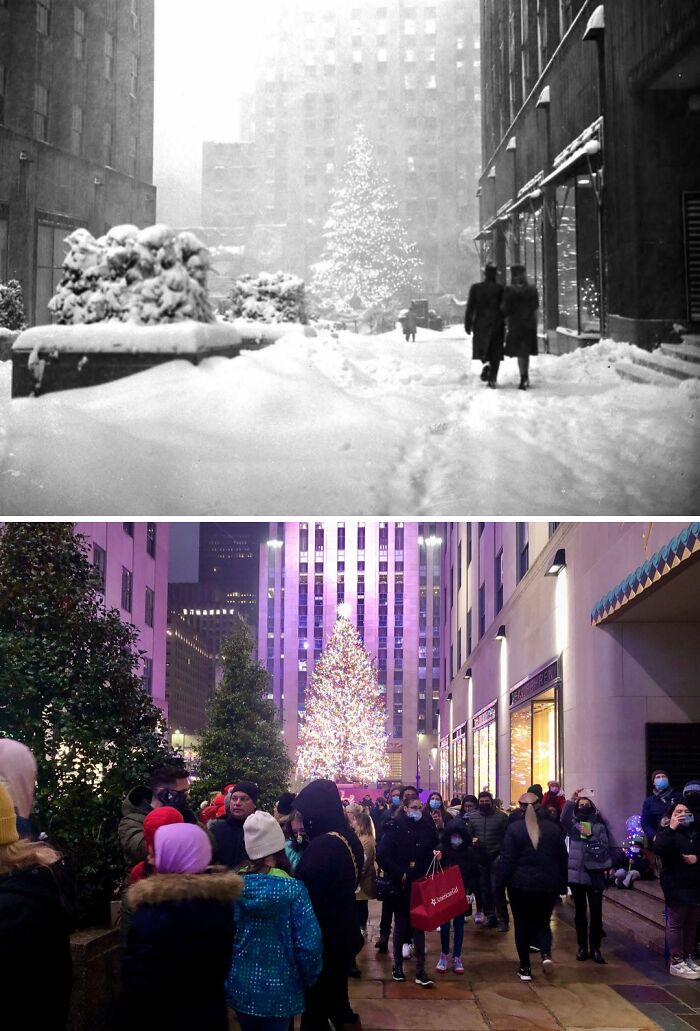
#29 1947 & Today
Looking west from 5th Ave between W 49th & W 50th Sts in Rockefeller Center, Manhattan.
.
The tradition of the annual Christmas tree in the heart of Rockefeller Center dates back to 1931 when the massive complex was still being constructed. On that year’s Christmas Eve, construction workers on the site pooled their money together and bought a 20-foot high balsam fir which they decorated with handmade garlands, strings of cranberries, and a few tin cans provided by the workers’ families. Two years later in 1933, Rockefeller Center decided to make the Christmas tree and annual tradition and the first official lighting ceremony was held that year with a 50-foot high balsam fir.
.
The annual tradition continued for the next few years even as World War II kicked off. During the war, the tree was decorated in patriotic colors of red, white, and blue, and in 1942, due to material shortages, 3 smaller trees instead of one massive one, were erected instead. The tree also went unlit 1944 until the war’s end due to the city’s wartime blackout regulations. 1951 was the first year the annual tree lighting was broadcast on television by NBC. The lighting broadcast on NBC now averages around 5-6 million viewers annually. The tree seen in the 1947 photo was 65-foot high Norwegian spruce from Deer Park, New York. This year’s tree is a 79-foot high Norwegian spruce that hails from Elkton, Maryland, the first time a tree from that state has been chosen as the official Rockefeller Center Christmas tree.
© Photo: nyc.beforeandafter
#30 1940’s & Today
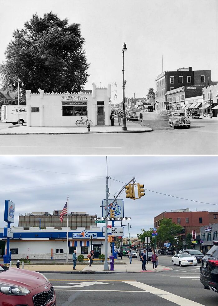
Looking north from the SW corner of Northern Blvd & Bell Blvd in Bayside, Queens.
The original White Castle restaurant seen in the old photo opened on this busy Bayside corner back in 1932. Before McDonald’s and Burger King came around in the 40’s and 50’s, respectively, White Castle—founded in 1921 and known for its 5 cent square hamburgers and innovative food assembly process—reigned supreme as America’s premier fast food chain. In the early days, White Castle’s castle-shaped locations were small, measuring no more than 200 sq. ft., (18.581 m²). Due to this reduced seating capacity, customers were encouraged to live by the company’s slogan “Buy ‘em by the sack”, where one could buy a sack of five burgers to take out instead of dining in the restaurant.
The 1932 White Castle building was torn down in the 1960’s in order to expand seating capacity. In the 80’s, after burning down in a fire, the new restaurant was moved slightly north of its original corner location in order to accommodate a drive-thru. Though the original 30’s building is gone, it’s amazing that this location has remained active for over 90 years.
© Photo: nyc.beforeandafter
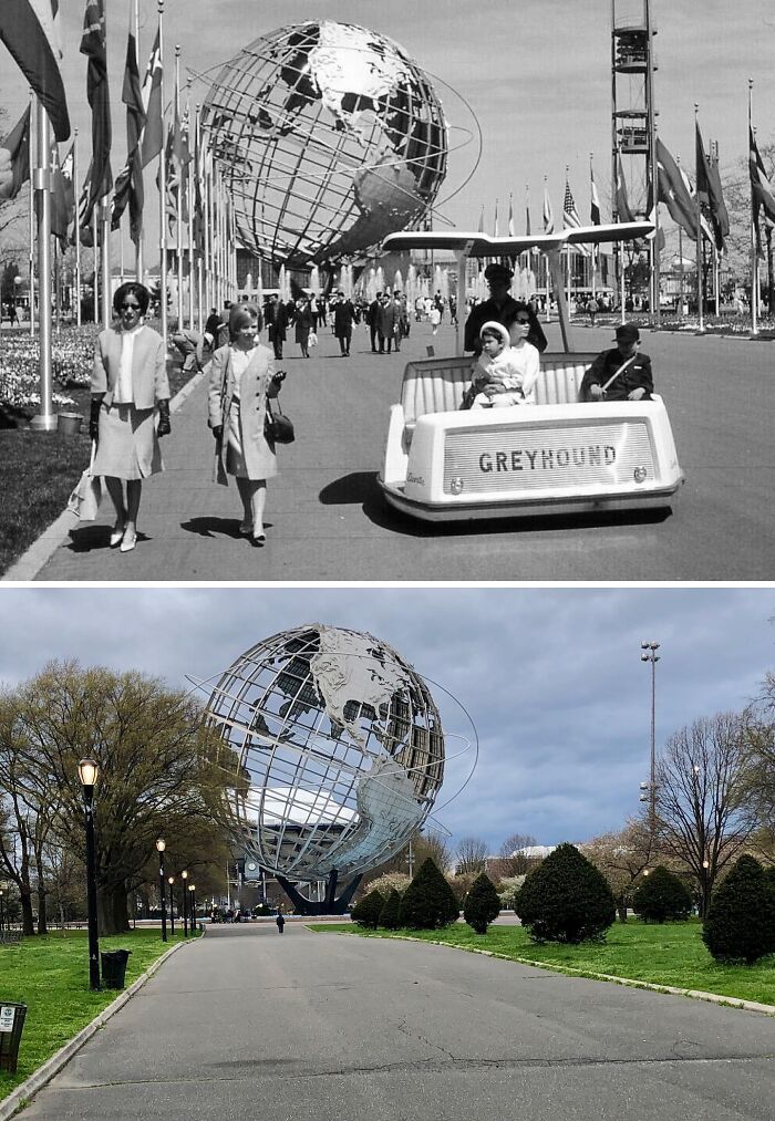
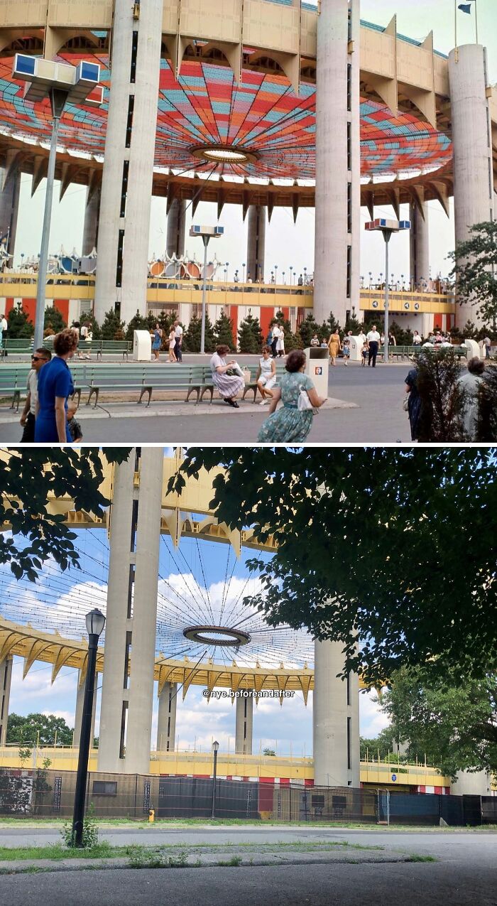
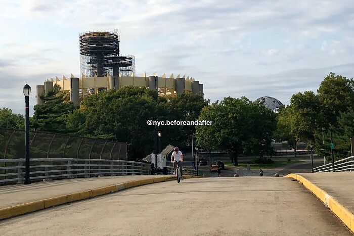
#31 1964 & Today
Looking north toward the Unisphere from United Nations Ave S in Flushing Meadows-Corona Park, Queens.
Today marks the 60th anniversary of the opening of the 1964 World’s Fair! Spread across 646 acres of Flushing Meadows, 80 nations, 24 US states and 45 corporations participated in the Fair whose central theme was “Peace Through Understanding”. To house all the attractions and exhibits, 140 pavilions were built as well as 110 different restaurants which offered visitors the opportunity to try and enjoy cuisines from across the globe. By the time the fair closed in October 1965, over 51 million people had visited.
The focal point and symbol of the World’s Fair was the Unisphere structure, a 12-story-high stainless steel representation of the globe set amidst The Fountain of the Planets . In fact, it’s considered to be the world’s largest representation of the globe. The Unisphere was built by U.S. Steel and took 110 days to complete with the structure being dedicated in March 1964, one month before the World’s Fair’s opening. The Unisphere was designated a NYC landmark in 1995.
To cover the ‘64 World’s Fair in just one post would be simply impossible and wouldn’t do it justice. That is why from now until October 2025, I am plan to create several posts highlighting different spots, pavilions, and attractions spread across the entire fair ground! So stay tuned as you’ll be seeing plenty more of Flushing Meadows for the next year and a half! And also, did you have the opportunity to visit the World’s Fair back in ‘64 or ‘65? Feel free to let me know in the comments section down below!
© Photo: nyc.beforeandafter
#32 1916 & Today
© Photo: nyc.beforeandafter
#33 Early 1950’s & Today
Looking north on Lexington Ave from E 102nd St in East Harlem, Manhattan.
.
Want a taste of the hilly San Franciscan experience without leaving NYC? Well, then head uptown to Duffy’s Hill, one of the steepest sections in Manhattan with a grade of 12.6%. Back in the day several trolley accidents would occur here as a result of the cars having to rapidly accelerate and decelerate when ascending or descending the hill. The trolleys are long gone but the M101, M102, & M103 bus routes still make the climb today.
.
Note in the old photo how Lexington Avenue was originally paved with Belgian Block and supported two-way traffic. This traffic pattern ended in 1960 when Lexington Avenue switched to only carrying one-way traffic southbound.
© Photo: nyc.beforeandafter
#34 1965 & Today
Looking east toward the New York State Pavilion in Flushing Meadows-Corona Park, Queens.
Built for the 1964-65 World’s Fair, the New York State Pavilion was designed by architects Phillip Johnson and Richard Foster, and structural engineer Lev Zetlin. It consisted of a theater called Theaterama, 3 observation towers, & a large elliptical structure called the Tent of Tomorrow. The 250 by 450 ft Tent seen in both photos originally featured a multi-colored suspension cable roof held up by sixteen 100-ft-tall concrete towers. The floor also featured a huge terrazzo highway map of New York State created by Texaco. The Pavilion was one of the Fair’s most visited attractions, and the Tent in particular was the site of many art exhibitions, concerts, & fashion shows.
Following the ‘65 season, the World’s Fair Corporation planned to demolish the Pavilion along with the Fair’s other large structures. However, Robert Moses and the state government lobbied for its preservation, with Moses in particular having been very enamored with the views offered by the observation towers & envisioned retaining the structure as a Queens landmark. In the end, the state provided $750k in Dec. 1965 in order to bring the buildings up to the city’s building codes, and ownership would be transferred to the city in 1968. The Tent became a concert venue for a time in 1969, and later operated as a roller rink from 1972-74 before closing due to damage to the roof. The roof was removed in the late 70’s, but the Tent would still be closed to the public in the 80’s due to safety concerns. Restoration efforts are currently underway at the Pavilion, with the Tent having been repainted, and with what remained of the terrazzo map on the floor preserved.
© Photo: nyc.beforeandafter
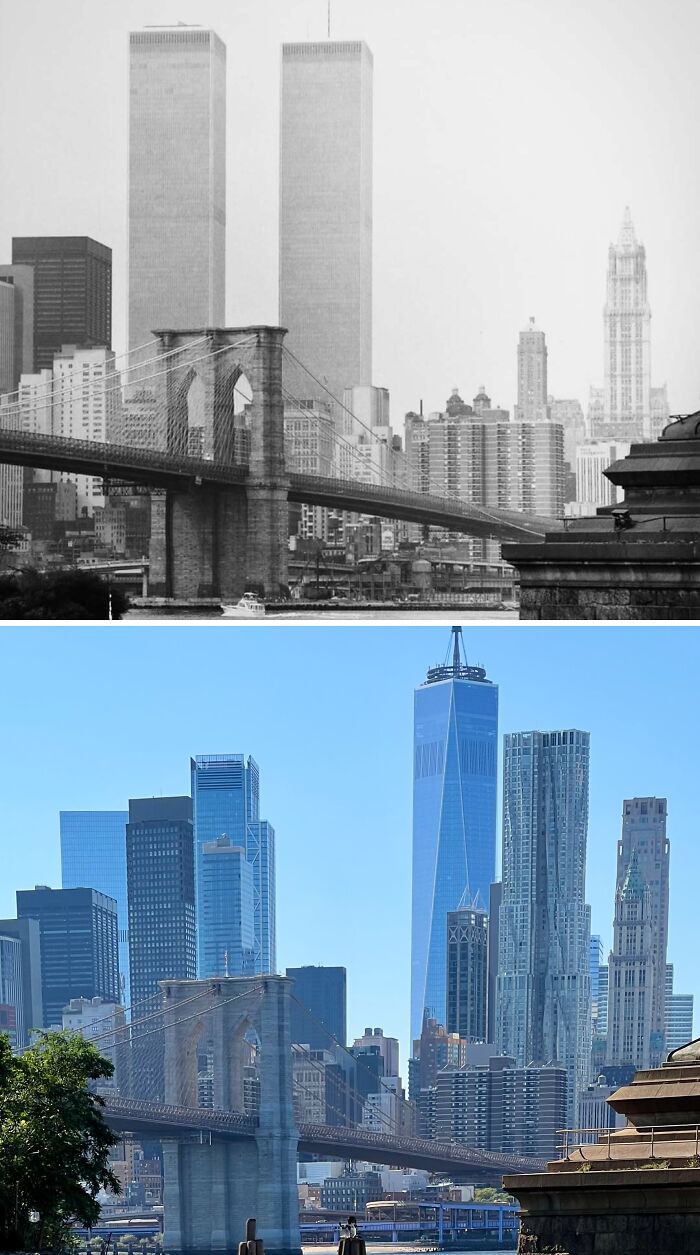
#35 1979 & Today
Facing SW across the East River from below the Manhattan Bridge in DUMBO, Brooklyn.
.
The Twin Towers formed part of a complex of 7 buildings that was collectively known as the World Trade Center. Designed by architect Minoru Yamasaki, construction of the WTC began in the late 60’s. The North Tower was completed in 1972 & the South Tower was finished in 1973. Each tower stood at 110 stories tall & were the tallest buildings in the city; 1 WTC being the taller of the two as a result of its antenna spire.Combined, the towers provided nearly 10 million sq ft of office space for about 35,000 people. The World Trade Center complex was truly a city within a city.
.
During the 3 decades that they stood, the Twin Towers became an integral part of the New York’s cityscape. And how could they not? When one thought of the city, the image of the Twin Towers came to mind just like Central Park, the Empire State Building, & the Statue of Liberty. If you watched any tv show or movie set in NYC during that time, chances are the Twin Towers are prominently featured in at least 1 scene. The feeling of awe & wonder one must’ve felt simply gazing up at them from the ground below will surely forever be ingrained in the minds of those who beheld them. One simply couldn’t imagine New York without them always being there until the end of time… Today, the new One World Trade Center, completed in 2014, stands just north of the former site of the North Tower & holds the title of the tallest building in the city and the Western Hemisphere.
© Photo: nyc.beforeandafter
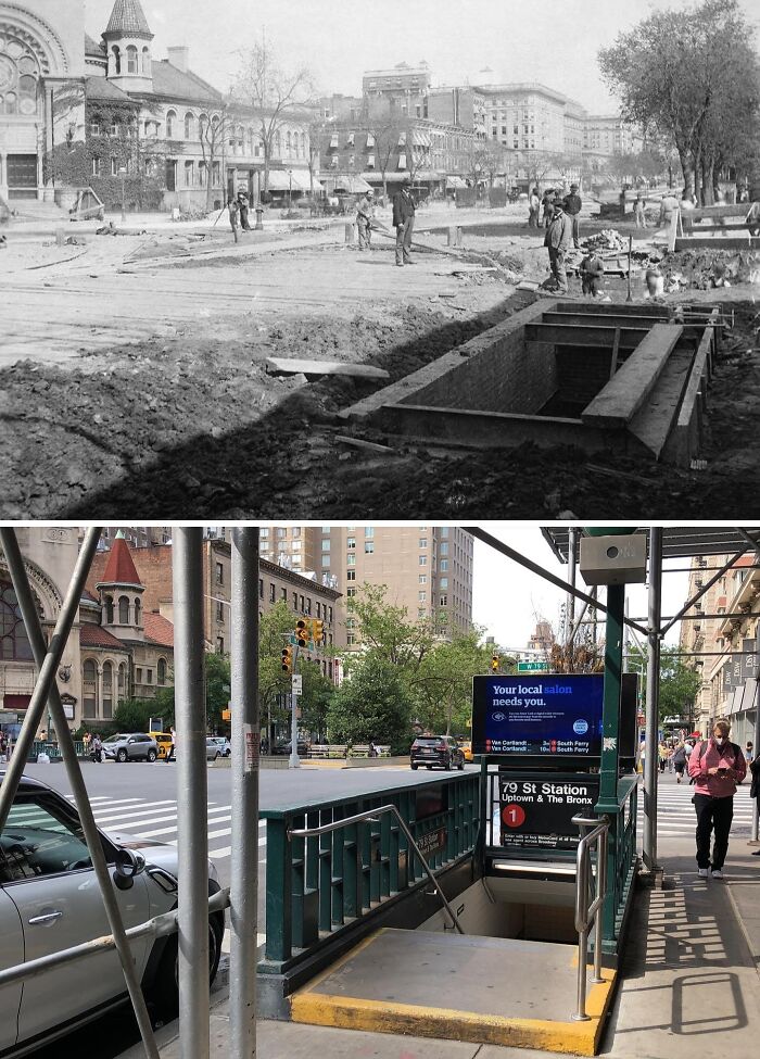
#36 1903 & Today
Looking north Broadway toward W 79th St on the Upper West Side, Manhattan.
.
The old photo was taken just 1 year prior to the opening of this section of the IRT Broadway-Seventh Avenue Line; part of the first subway line in New York City that ran from City Hall up to 145th Street. 79th Street is one of the original 28 stations from the subway’s inauguration and it looks as though it was still receiving finishing touches prior to its grand debut. 79th Street station was designated a NYC landmark in 1979 and added to the National Register of Historic Places in 2004.
.
The only other thing besides the station entrance remaining is the First Baptist Church in the City of New York on the upper left-hand side of both photos. The church was opened in 1894 and designed by George Keister, the man who would later go onto to the design the famous Apollo Theatre in Harlem. Keister designed the facade in an Italian Romanesque Revival style and situated the building at a 45-degree angle so that it would embrace the busy Broadway intersection. To this day the building is still active as a house of worship.
© Photo: nyc.beforeandafter
#37 1941 & Today
Looking NE at Broadway & Bedford Ave in Williamsburg, Brooklyn.
.
Despite all the changes that have taken place in Williamsburg in recent years, it’s amazing to see that all of the buildings seen in the old photo are still around today. The stunning Classical Revival style building seen on the right with its impressive dome is the Williamsburgh Savings Bank Building. It was completed in 1875 and designed by architect George B. Post, the man who’d later go on to design the New York Stock Exchange Building on Wall Street and the former Cornelius Vanderbilt II Mansion on 5th Avenue. The building was designated a NYC Landmark in 1966 and added to the National Register of Historic Places in 1980. Its interior also received city landmark status in 1996. Today, the former bank is a banquet hall.
.
Although no major changes to the buildings took place in all these years, that does not mean that the streetscape remained unchanged. Seen in the 1941 image is the demolition of the BMT Jamaica Line’s Broadway Spur. When it opened in 1888, the Jamaica Line originally started where Broadway began at the shoreline of the East River. There existed two stations: Broadway Ferry and Driggs Avenue, before the line continued east toward the existing Marcy Avenue station. Once the Williamsburg Bridge opened in 1903, service along Broadway west of Marcy Avenue was greatly reduced with most trains now heading over the bridge and into Manhattan. Broadway Ferry and Driggs Avenue closed in 1916 and the tracks were abandoned but the elevated section west of Marcy Avenue would remain intact for over 2 decades before being ultimately demolished in 1941.
© Photo: nyc.beforeandafter
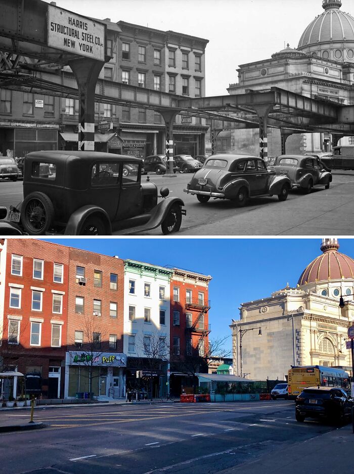
#38 1915 & Today
Looking east at the NE corner of Broadway & W 40th St in Midtown, Manhattan.
.
Although the building on the left side of the old photo has long since been demolished, it’s nice to see that several other buildings over on the right still stand today. Note the multiple different businesses that the old building housed; including a railroad office, a shoe store, a vaudeville agency, a detective agency, and a Secret Service Bureau office. If someoneone ever finds a way to travel back to the past and needs an ideal setting for a novel or a silent film, this is certainly a perfect candidate!
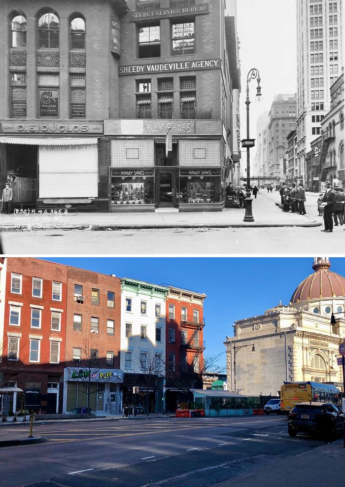
© Photo: nyc.beforeandafter
#39 1940 & Today
© Photo: nyc.beforeandafter
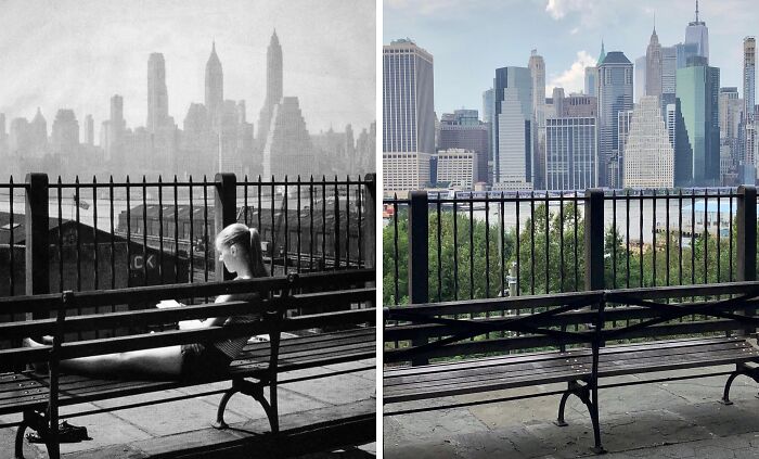
#40 1957 & Today
Looking west across the East River from the Brooklyn Heights Promenade in Brooklyn Heights, Brooklyn.
.
Despite how much the Lower Manhattan has changed over the course of the mid-20th century up to the present, the 3 skyscrapers featured prominently in the old photo still stand today! From left to right are 20 Exchange Place, 40 Wall Street, & 70 Pine Street. Of the three, 70 Pine Street is the tallest and was the tallest building in Lower Manhattan until the completion of the Twin Towers in the early 1970s. After the 9/11 attacks, it regained and would retain the title of tallest in Lower Manhattan until the completion of the new One World Trade Center in 2014, which can be seen just to the right of it in the present-day photo.
.
Also, note in the old photo the presence of shipping piers and warehouses below the promenade along the East River waterfront. Since colonial times, Brooklyn has been an important shipping port with goods arriving and departing to and from destinations all over the globe. Many of the warehouses would be demolished in the years after the photo was taken as shipping gradually moved elsewhere to accommodate larger container ships. The space where they now stood now forms part of Brooklyn Bridge Park.
.
I have no clue who the girl in the photo is, but judging from her age, if she is still alive she’d be in her late-70’s to mid-80’s. If anyone has any info on who she might be feel free to leave it in the comments section down below!
© Photo: nyc.beforeandafter
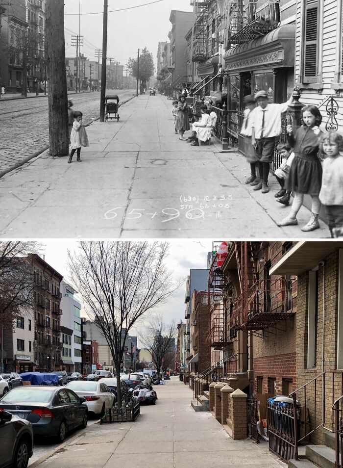
#41 1946 & Today
Looking south down Pike St at Madison St on the Lower East Side, Manhattan.
.
Well… uh… the Manhattan Bridge is still there! Tragically, all of the old tenement buildings seen in the old photo were demolished around the early 1960’s as part of the city’s urban renewal policy and as part of the widening of Pike Street. On the left side of the present-day photo is the Rutgers Houses public housing development. The glass structure behind the housing complex is One Manhattan Square which was completed in 2019.
© Photo: nyc.beforeandafter
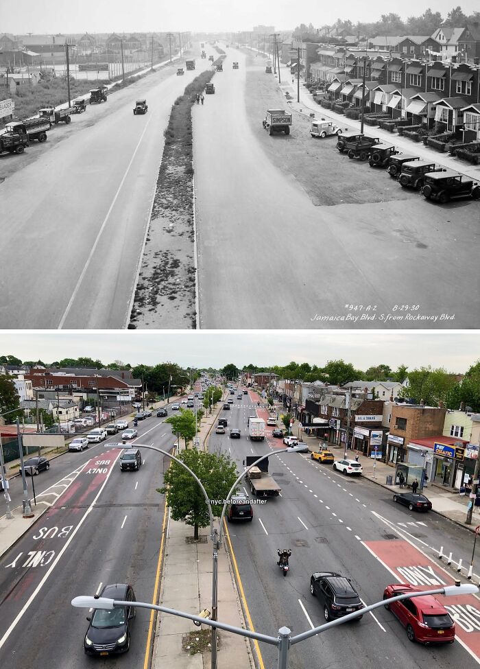
#42 1930 & Today
Looking south down Cross Bay Blvd from the elevated Rockaway Blvd station in Ozone Park, Queens.
It’s hard to imagine busy Cross Bay Boulevard looking as quaint and tranquil as it did in the 30’s, but alas it once was. As locals living along the boulevard’s length can attest, it can get pretty crowded nowadays, especially in the summertime when people make the exodus out of the concrete jungle via car or the Q53 or Q52 buses for a day of fun in the sun down at Rock, Rock, Rockaway Beach.
At the time that the old photo was taken the boulevard had only been completed some 5 years earlier and it was known as Jamaica Bay Boulevard. The name was subsequently changed to Cross Bay Boulevard in subsequent years likely due to the opening of the original Cross Bay Veterans Memorial Bridge in 1929 which allowed drivers on the boulevard to cross over Jamaica Bay from Broad Channel to the Rockaways for the first time.
© Photo: nyc.beforeandafter
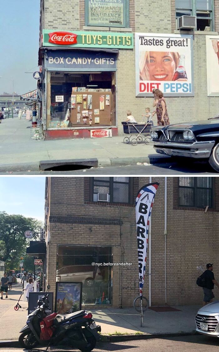
#43 Mid 1960’s & Today
Looking west at the NW corner of 30th Ave & 34th St in Astoria, Queens.
A view of days gone by in Astoria as two women and children walk past what appears to have been an old school pharmacy. Interestingly, a Coca-Cola sign is on the storefront while an advert for Diet Pepsi is on the side. I guess the owner was playing both sides so they’d always come out on top 😅
Also, note how even after all these years there is still a window A/C unit installed on the 2nd floor of the building. Difficult to get through the summer without one!
© Photo: nyc.beforeandafter
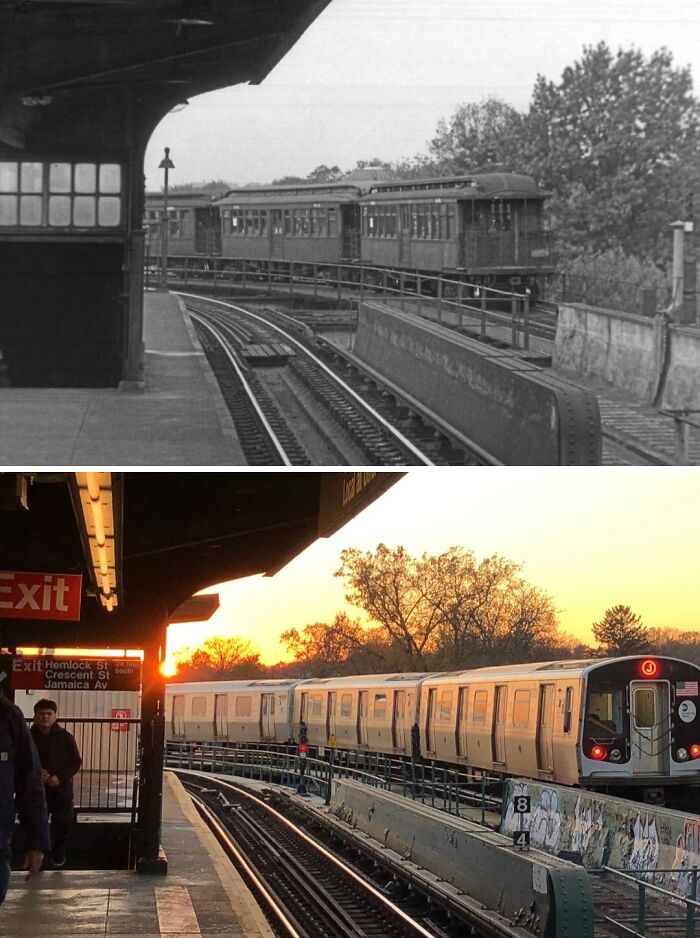
#44 Unknown & Today
Looking west from the eastbound platform of the Cypress Hills station in Cypress Hills, Brooklyn.
.
The Cypress Hills station on the BMT Jamaica Line opened in its current form in 1917 and is the line’s last stop in Brooklyn before crossing into Queens. The line between Cypress Hills and the Crescent Street station also traverses 2 of the tightest curves in the entire subway system as trains turn from Fulton Street onto Crescent Street before turning onto Jamaica Avenue several blocks north.
.
Unfortunately, I’m not much of an NYC subway car expert so if anyone knows the type of cars featured in the old photo feel free to let me know in the comments! It might even help narrow down a date as to when this photo was taken!
© Photo: nyc.beforeandafter
#45 1955 & Today
Looking east at Delancey St S toward the FDR Drive on the Lower East Side, Manhattan.
.
A few weeks back I featured a 1950’s photo showing a group of teenage girls hanging out and dancing on a street corner in Yorkville—a post I affectionately dubbed ‘East Side Story’. Well, now we have the inverse of that post with what I’ll call ‘Lower East Side Story’ 😅
.
In the 1955 image, we see a gang of teenage boys hanging out in the shadow of the Williamsburg Bridge, just a hop, skip and a jump away from the East River on the other side of the FDR Drive. Sadly, (as with the girls in my ‘East Side Story’ post) I do not know the identities of any of the boys featured in the photo, but given their ages, it is reasonable to assume that someone might recognize one of them as their father, grandfather, uncle, etc. If anyone has any information that’ll help identify one or several of these boys, please leave it in the comments section down below or send me a DM!
.
Lastly, although there is virtually no connection between the girls in my previous post and the boys in this one, in my head I like to think that both photos were taken before both groups met up with each other for a night out on the town. After all, who’s to say these guys weren’t talking about cruising up the FDR Drive to meet up with those ‘Uptown Girls’ 😂
© Photo: nyc.beforeandafter
#46 1964 & Today
Looking west on W 50th St towards Broadway in the Theater District, Manhattan.
Though this spot still marks the entrance to the 50th Street station on the (1) line, gone are the large and ornate kiosks which once adorned the entrances to subway stations built by the Interborough Rapid Transit Company (IRT) in the early 20th century. The large cast iron and glass kiosks were built by the architectural firm of Heins & LaFarge, which the IRT hired to design its stations for its first subway line in 1904. The kiosks were inspired by similar-looking structures built in the late 1890’s for the Budapest Metro in Hungary. Note the slight differences in the roofs of each kiosk seen in the old photo. The slight difference was actually a design choice by Heins & LaFarge with the domed roof ones with leaf-like shingles being for entrances while the four-sided peaked ones being for exits.
Sadly, the city opted to remove the kiosks during the 1960’s citing complaints from drivers that the structures posed acted as traffic hazards by obstructing sightlines. This was also the reason that led to the removal of the Budapest Metro kiosks in the 1920’s. The kiosks at the 50th Street station were likely removed not long after the old photo was taken. Also, note how the entrance in the foreground has since been completely removed. Today, the only place in the city where one can see what these grand kiosks once looked like is over at the Astor Place station on the (6) line, though it should be noted that the kiosk there is actually a replica and not an original structure. Still, it’s better than nothing.

© Photo: nyc.beforeandafter
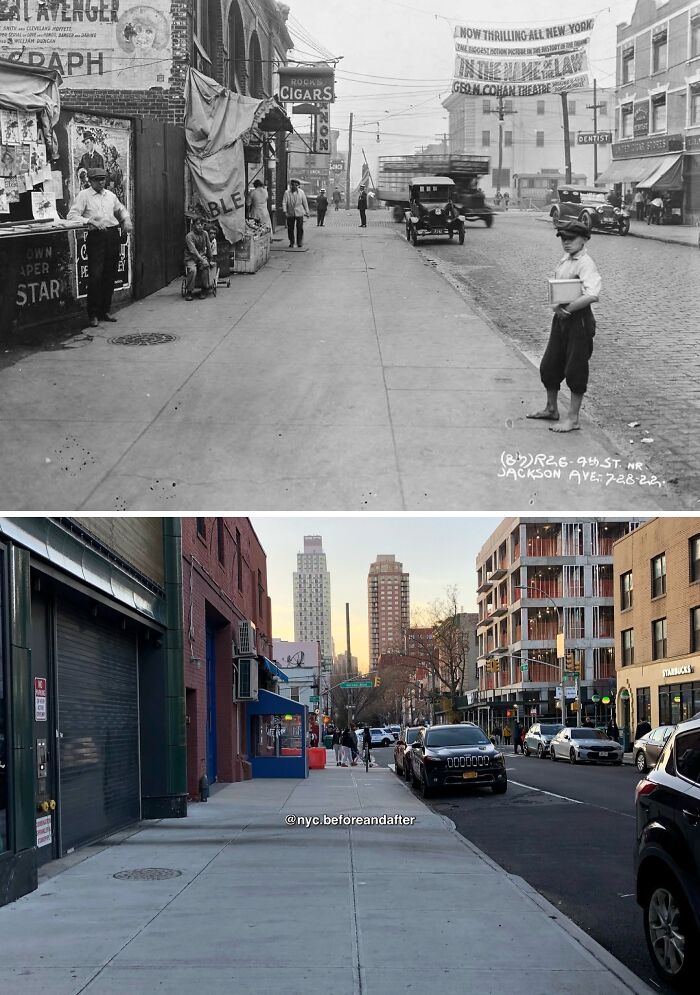
#47 1922 & Today
Looking west on 50th Ave toward Vernon Blvd in Long Island City, Queens.
It’s incredible to see just how much this slice of LIC (also known as Hunters Point) has changed over the past 100 years. However, vestiges of the neighborhood of old still remain such as the building on the right, the building straight ahead across Vernon Blvd, the 108th police precinct also across the street on the right and even the building with the arches on the left. Look closely and you can still vaguely make out the outline of the arches on the upper floor!
The large banner stretching across 50th Ave in the old photo was an advertisement for the 1922 silent film “In The Name Of The Law”. The film’s plot mainly revolved around a San Francisco policeman’s dramatic struggle to balance his family life with his duties as an officer. It premiered at the since-demolished George M. Cohan Theatre at Broadway & 43rd St in Manhattan. Due to its positive and serious portrayal of law enforcement, the film’s producers partnered with police departments across the country to help with its promotion. It’s perhaps no coincidence then that the banner was located just across the street from a police precinct.
Last but not least, note the people in the old photo, especially the shoeless boy standing on the curb. It serves as a reminder that beneath the veneer of a booming city, poverty was unfortunately still abound. One can only hope that the boy managed to find a way to climb up the social ladder later on and live a long fulfilling life, especially as the Great Depression was just under a decade away. May he and the others seen in the old photo Rest In Peace.
© Photo: nyc.beforeandafter
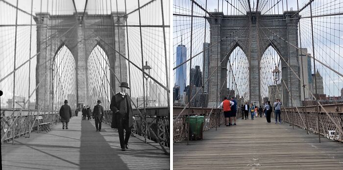
#48 1900’s & Today
Looking west on the Brooklyn Bridge toward the Manhattan Tower, Manhattan.
.
On this day 140 years ago, May 24, 1883, the Brooklyn Bridge officially opened to the public for the first time & at last provided a connection across the East River between New York City & the then city of Brooklyn after 14 years of construction. Over 150k people turned out & crossed the span on that day with festivities lasting well into the night & ships in the East River firing off hundreds of fireworks that lit up the sky.
.
The Brooklyn Bridge was the brainchild of civil engineer John A. Roebling who drew up his design for the span in 1867. Tragically, he died of tetanus in 1869, never living to see its completion. His son Washington then set out to complete his father’s project. Hundreds of men worked around the clock both above ground & underwater with many of those working underwater falling victim to decompression sickness, including Washington in 1870 with him being bedridden for years afterward. During his ailment, his wife Emily would essentially take over his work by overseeing construction & managing day-to-day operations while reporting back to him. That the bridge was completed at all is due in large part to Emily’s management, so it was only fitting that she was chosen to become the 1st person to officially cross the bridge on opening day.
.
Today, the Brooklyn Bridge is an iconic New York & American landmark with over 160k vehicles; 30k pedestrians; and 4,000 cyclists crossing its span daily. Truly, it would be hard to imagine New York having become the metropolis it is today without the Brooklyn Bridge; an enduring testament to the city’s unbreakable spirit & to what America as a nation can achieve when her people all come together.
© Photo: nyc.beforeandafter
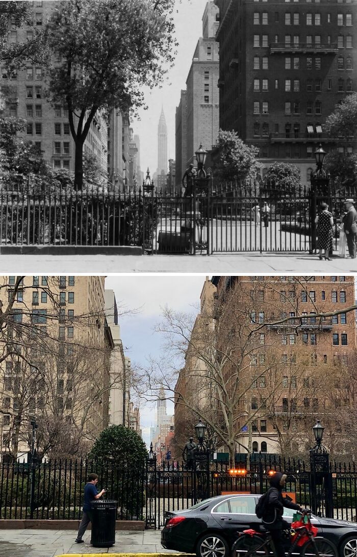
#49 1932 & Today
Looking north at Irving Pl & Gramercy Park S in Gramercy Park, Manhattan.
.
Today’s post is an extremely rare example depicting a Manhattan view that is practically unchanged after 91 years! Indeed, practically all of the buildings seen in the 1932 photo still stand today. The Chrysler Building in the background had only been completed 2 years earlier when the old photo was taken and it held the title of the 2nd-tallest building in the world. Today, it doesn’t even crack the top 10 in the city. Gramercy Park has also remained exclusive even after all these years with only a select few possessing a key to unlock the gates and enter the private park.
.
.
Fan of my work? Consider supporting the page by tapping the link in my bio! Buy me a coffee or become a Patreon supporter to get exclusive perks.
© Photo: nyc.beforeandafter
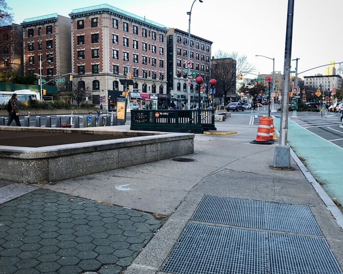
#50 1925 & Today
Looking north on St. Nicholas Ave from W 167th St in Washington Heights, Manhattan.
.
The scene remains practically unchanged today save for the absence of the quaint little newsstands (note a second smaller one behind the staircase in the 1925 photo) and the fact that the staircase leading down to the 168th Street Station has been moved a bit further up from its original position. That staircase also now leads up from an exit-only turnstile hence why it says “No entry”. If anyone has any idea when the staircase was moved feel free to let me know in the comments!
© Photo: nyc.beforeandafter
#51 1915 & Today
© Photo: nyc.beforeandafter
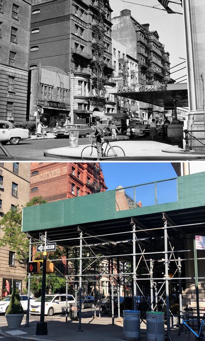
#52 1958 & Today
Looking east at the intersection of Montague St & Hicks St in Brooklyn Heights, Brooklyn.
.
Although, thankfully, all of the buildings seen in the 1958 photo are still standing, the hideous scaffolding surrounding the former Hotel Bossert certainly detracts from what would otherwise be a wholesome present-day scene.
.
The 14-story, 224-room hotel was built in 1909 by a local lumber magnate named Louis Bossert. In its heyday, the Bossert was nicknamed “The Waldorf-Astoria of Brooklyn” as it was one of the borough’s most opulent hotels. In the 1920’s, a restaurant called Marine Roof opened on the hotel’s roof offering guests incredible panoramic views of Brooklyn and Lower Manhattan across the East River. In 1955, the Brooklyn Dodgers celebrated their first and only World Series title whilst in Brooklyn at the Bossert.
.
Sadly, the Bossert saw a decline in the years following the 1950’s and the building was ultimately bought by the Jehovah’s Witnesses in 1988. The Witnesses were responsible for massive renovations that helped restore much of the former hotel’s charm of decades past that had long since been left to rot and decay. The building was once again sold in 2012 to Joseph Chetrit and David Bistricer who planned to turn the Bossert into a boutique hotel. Unfortunately, practically no actions to reopen the hotel were taken and the building has remained abandoned to this day. According to a Brooklyn Eagle article from Sep. 13, 2022, the building will soon be up for auction after the owners defaulted on a $112 million mortgage. Thus, the future of the former Hotel Bossert remains, as of now, uncertain.
© Photo: nyc.beforeandafter
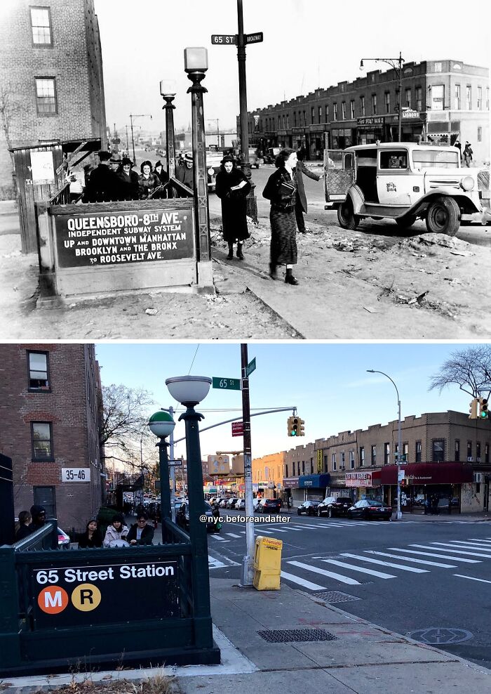
#53 1936 & Today
Looking west at the SE corner of Broadway & 65th St in Woodside, Queens.
The old photo shows a group of people gathered around one of the entrances leading down to the 65th Street station. The station opened in 1933 as part of the IND Queens Boulevard Line’s first phase from Jackson Heights-Roosevelt Avenue to Queens Plaza and on to Manhattan via the 53rd Street tunnel. Built during the height of the Great Depression, the opening of the line was tremendously influential in spurring development throughout the various Queens neighborhoods it ran through, including Woodside. As early as the 1920’s, when plans for a Queens subway line with direct access to Manhattan were first proposed, speculators began buying up what was then still mostly rural farmland and properties all along the line’s proposed route in order to turn a profit. The apartment building in the background, as well as the row of mixed commercial and residential buildings across the street were all built just a few years prior to the line’s opening.
Though I can’t be 100 percent certain, I believe that this particular old photo was taken on December 31st, 1936. My reasoning for this is that that day marked the opening of the second phase of the Queens Boulevard Line east from Jackson Heights-Roosevelt Avenue to Kew Gardens-Union Turnpike. The policeman standing in front of what looks to be the cordoned-off entrance, as well as the people’s excited expressions, seem to suggest a celebratory occasion.
© Photo: nyc.beforeandafter
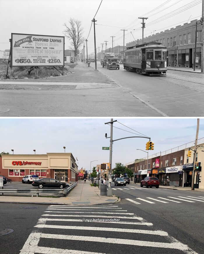
#54 1931 & Today
Looking east on Metropolitan Ave from 69th Ave in Forest Hills, Queens.
When the old photo was taken, this part of Forest Hills was experiencing a building boom with commercial buildings popping up all along Metropolitan Avenue as well as many detached-single family homes on the adjacent side streets. The large billboard seen across the street was for Stafford Lawns which today is known as Forest Hills Gardens; one of the city’s most upscale neighborhoods which was modeled on the garden cities of England and features scores of beautiful Tudor-style homes. The listing price of $9550 in 1931 would be roughly equivalent to $195k in 2024. Today, those homes are all worth upwards of $1.5 million. Also, note the tagline advertising the neighborhood as 14 minutes from New York (Manhattan). That has to have been referring to the time it takes via the LIRR because there’s just no other way that’s even remotely true 😅
As the outer boroughs gradually began to experience urban development during the first half of the 20th century, a major factor which determined a neighborhood’s attractiveness to potential buyers was access to public transportation, particularly subway and streetcar access. The trolley seen in the 1931 photo was the Metropolitan Avenue Line operated by the BMT which ran from Williamsburg, Brooklyn all the way east to Jamaica, Queens. After shutting down in 1949, the line was replaced by the Q54 bus route which to this day continues to be a very important route for commuters in Queens and Brooklyn even if the wait times do tend to be a bit high.
© Photo: nyc.beforeandafter
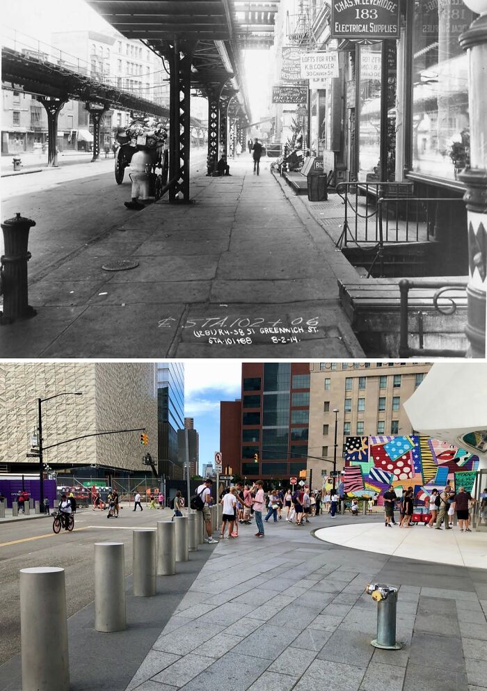
#55 1914 & Today
Looking north on Greenwich St from Dey St at the World Trade Center, Manhattan.
.
In this post we have an example of a complete transformation of an area since not one thing from the original photo remains standing today. All of the buildings formed part of a lively working class area which would become the iconic “Radio Row” neighborhood in the 1920’s, so-called because of the many radio-related stores selling radios and electronic parts that would operated there. The entire neighborhood was demolished in the 1960’s to make way for the original World Trade Center. Today, the site is home to the new and current World Trade Center with the still-uncompleted Performing Arts Center on the left and the white tip of the Oculus Transportation Hub on the upper right.
.
Another notable change today is the absence of the two elevated structures flanking Greenwich Street in the 1914 photo. The structures were erected in the 1870’s by the New York Elevated Railroad company as part of the construction of an elevated railway line that would mostly run along 9th Avenue on Manhattan’s west side. The line would later be taken over by the IRT in 1903 and became the IRT Ninth Avenue Line. This line was rather unique as it was one of the only lines to have sections where the tracks were located above the sidewalks rather than above the roadway. The section of the line between South Ferry and 145th Street was closed and demolished in 1940.
© Photo: nyc.beforeandafter
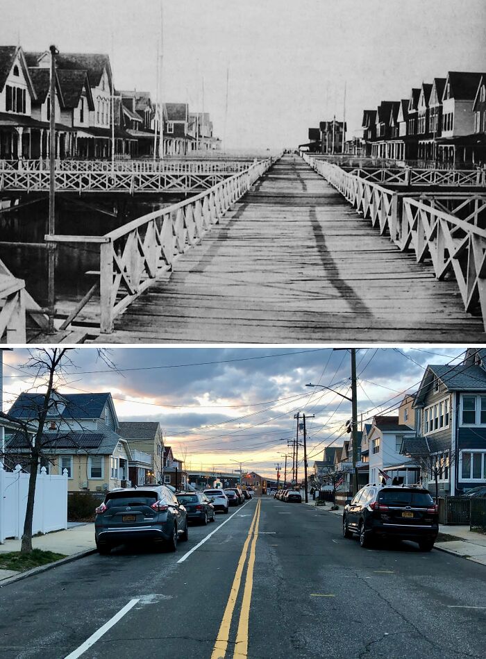
#56 1900-1920 & Today
Looking north on Beach 92nd St from the Rockaway Freeway in Rockaway Beach, Queens.
.
With the opening of the Long Island Rail Road’s Rockaway Beach Branch in 1880, the Rockaways’ exploded in popularity for well-to-do New Yorkers who sought to escape the city during the hot and muggy summer months. In the Rockaways—an 11-mile-long narrow peninsula situated alongside the cool and breezy Atlantic Ocean that was easily accessible via railroad—they found refuge. It was sometime in the 1870’s that the first wooden pier was built jutting out over the waters of Jamaica Bay at the present site. The pier was known as the Holland Pier; its name in reference to the Holland family, one of early Rockaways’ most influential families who owned some 65 acres of land in the peninsula at the time.
.
The Holland Pier seen in the old photo was the second iteration as the original structure was badly damaged by a storm in 1884. Not long afterward, summer homes, along with boat and fishing clubs, began to spring up on stilts on both sides of the pier with walkways leading to each structure. This would remain the status quo for nearly 40 years until 1923 when the city took the decision to fill in a huge swath of the bayfront from Beach 88th St to Beach 116th St with dredged sand in order to create more land, and to better protect against storms and flooding. Naturally, this spelled the end for the Holland Pier. The pier was subsequently taken down and the buildings that once flanked it were left landlocked. Where the pier once stood now exists Beach 92nd Street, with the waters of Jamaica Bay now being located across busy Beach Channel Drive some 700 feet away from where the pier originally began.
© Photo: nyc.beforeandafter
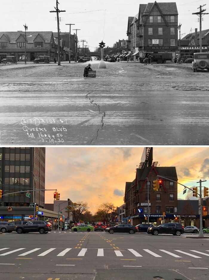
#57 1930 & Today
Looking south down 71st Ave across Queens Blvd in Forest Hills, Queens.
.
71st Avenue, also known as Continental Avenue, serves as a sort of gateway from the hustle and bustle of Queens Boulevard down into the quaint and tranquil Forest Hills Gardens neighborhood with its iconic Tudor style homes. One need not proceed beyond the LIRR trestle further down 71st Ave to get a glimpse of the Tudor architecture, however, as can be seen by the building on the right side of both photos. However, if one already finds themselves in the area, then a visit to Forest Hills Gardens is definitely a must-do!
© Photo: nyc.beforeandafter
#58 1964 & Today
Looking north from the LIE bridge in Flushing Meadows-Corona Park, Queens.
The old photo was taken during the 1964 New York World’s Fair and shows a view of the fair from a flag-lined bridge. The metallic, cylindrical structure seen in the distance on the right side was the Astral Fountain. The fountain featured a column of water which shot up 70 feet high & was surrounded by a metallic framework featuring metal stars. The site of the fountain is today home to a skatepark.
.
Completed in 1964, the New York State Pavilion was one of the World’s Fair’s most iconic & visited attractions and functioned as the site of the government of New York State’s exhibits for the fair’s duration. The idea for the pavilion came from the ever-contentious Robert Moses who was the city’s park commissioner and also president of the World’s Fair Corporation. 24 US states ended up building pavilions for the fair and not wanting to be upstaged on home turf, New York’s was designed to be the largest one. The pavilion was composed of three parts: a large oval-shaped structure known as the Tent of Tomorrow, 3 observation towers, and a cinema called Theaterama.
After the fair ended in 1965, the city intended to demolish the Pavilion like almost all of the other exhibits and attractions. However, in an ironic twist of fate, it was Robert Moses—along with the state government—who fought for its preservation as a permanent feature of Flushing Meadows. The Tent of Tomorrow later became a concert venue & a roller rink in the late 60’s and early 70’s before it was closed and abandoned due to concerns with the structure’s roof. The observation towers have also been abandoned since the 60’s. Only Theaterama continues to be in use today and is now known as the Queens Theatre.
© Photo: nyc.beforeandafter
#59 1919 & Today
Looking north on W 6th St at Sheepshead Bay Rd in Coney Island, Brooklyn.
.
The old photo was taken during construction of the elevated BMT Culver Line through south Brooklyn. This section of the line from Avenue X to Coney Island-Stillwell Avenue would open in 1920. Today, the line still operates but has formed part of the Independent Subway System since 1933 and is known as the IND Culver Line or more commonly, the F train.
© Photo: nyc.beforeandafter
#60 1953 & Today
Looking west along 45th Ave from the elevated Court Square station in Long Island City, Queens.
.
Thankfully, many of the historic townhomes seen along both sides of 45th Avenue have survived into the present day and today form part of the city’s Hunters Point Historic District. I’d say the 19th century buildings that form this district along this small stretch of 45th Avenue are overlooked by most in the city, which I doubt would be the case if this was in Manhattan or Brooklyn. Next time you’re in the area I recommend taking a walk down this street and immersing yourself in the historic charm that still exists amongst all new glass condos and high rises.
.
Another major change seen today is the presence of street trees which line the road. In fact, I specifically came to this spot during the winter months as the foliage would largely obscure the view in the summer. And speaking of view, note how much the Manhattan skyline in the distance has evolved. The Chrysler Building on the upper left once dominated the skyline. Nowadays, it has been surpassed by many other buildings around it. The Chrysler Building was the 2nd-tallest building in the city at the time. Today, it doesn’t even crack the top 10.
.
Lastly, check out the price for the parking lot on the lower left side of the old photo. 40 cents!
© Photo: nyc.beforeandafter
#61 1929 & Today
Looking east on Northern Blvd toward Woodside Ave in Woodside, Queens.
.
The building seen in the background of both photos is part of a former trolley barn for the New York and Queens Railway Company. It was built in 1896 and was a busy transportation hub in its day and was the largest car barn in Queens with trolleys from Flushing, Long Island City, and even as far away as Jamaica and College Point being serviced there. The last trolley that operated out of the terminal ran on Sep. 5, 1937, with the trolleys being replaced by motorized buses thereafter.
.
Sadly, much of the complex was torn down in the 1980’s to make way for a shopping center. The clock tower and waiting room seen in the background were also scheduled to be demolished, but thanks to the work of several preservationists, they were saved. For many years, a Pizza Hut occupied the building, but as of now, it is currently empty. Today, the shopping center is known as Tower Square & if you get up close to the building you can still see signs for “N.Y. and Queens Co. Ry. Co.” and “Waiting Room” chiseled on the exterior walls.
© Photo: nyc.beforeandafter
#62 1915 & Today
Looking west along Queens Blvd from 40th St in Sunnyside, Queens.
.
The old photo shows the IRT Flushing Line’s 40th Street-Lowery Street station 2 years prior to its completion and opening. The station is one of 3 that were built atop a nearly mile-long viaduct running above the center of Queens Boulevard. Note the empty land seen on the left and behind the viaduct in the old photo. The landscape would soon change as the subway line’s opening sparked a building a boom around the line’s route.
© Photo: nyc.beforeandafter
#63 1922 & Today
Looking west at W 41st St & 8th Ave in Hell’s Kitchen, Manhattan.
.
Nothing in the immediate vicinity of where the 1922 photo was taken remains standing today. Without knowing the streets beforehand one would be find it hard to believe that these 2 images were taken in the exact same spot, but alas, it is so. The huge swathes of buildings seen in the background of the old photo were demolished to make way for the Port Authority Bus Terminal which opened in 1950.
.
Do you see the church spire off in the distance in the 1922 image? That church — known as the Church of Sts. Cyril & Methodius and St. Raphael — opened back in 1903 and actually still stands today on W 41st St, west of 10th Ave! The church is still active and offers services in both English and Croatian!
© Photo: nyc.beforeandafter
#64 1935 & Today
The NW corner of Mulberry St & Prince St in Nolita, Manhattan.
.
Although the old corner building, as well as the small one up the block are no longer around, it’s nonetheless refreshing to see that many of the surrounding buildings still stand after all these years. Also, note the painted advertisement on the side of the apartment building in the old photo and how traces of paint are still visible today.
© Photo: nyc.beforeandafter
#65 1913 & Today
Looking north on the west side of Broadway toward E 14th St in Union Square, Manhattan.
.
The 16-story Renaissance Revival building seen in the background of both of photos is the Bank of the Metropolis Building. It was built on the corner of E 16th Street and Union Square West by the bank in 1903. The ground floor contained the bank with the upper floors being leased as office space to various tenants. From 1975 to 1979, the building’s upper floors were converted for residential use. In 1996, the former bank space on the ground floor became occupied by a restaurant known as the Blue Water Grill, though it recently closed in 2019 due to rising rents. The building was made a NYC landmark in 1988 and added to the National Register Of Historic Places in 2003.
.
Meanwhile, the building seen on the left-hand side of the old photo is the Domestic Sewing Machine Company Building. It was built in 1873 and served primarily as a headquarters for the sewing company for which it was named after. The first floor featured showrooms with sewing machines exhibited with the second floor being dedicated to the pattern department. Floors 4 through 8 contained office space. The building was the tallest in New York when it was built and its showrooms were very popular with the city’s female shoppers. The company went bankrupt in 1893 and the building became occupied by numerous smaller shops and businesses, with the ground floor housing a shoe store at the time the 1913 photo was taken. Then, in the 1920s, the building was demolished and replaced with the current 20-story building, 853 Broadway.
© Photo: nyc.beforeandafter
#66 1908 & Today
Looking north on the southbound platform of the Wall Street (4,5) station in the Financial District, Manhattan.
.
The Wall Street station on the IRT Lexington Avenue Line is one of the subway system’s oldest stations, having been opened in 1905. And although the station has been renovated to introduce some modern amenities during the course of its nearly 120 years of operation, much of the station’s original charm and historic character has been retained, such as an original wooden ticket booth and the station’s original plaques and mosaics. Unfortunately, those features aren’t visible from this particular spot today thanks to the metal barriers. The lack of metal barriers in the old photo was due to the fact that back in the day passengers would descend into a station via the stairwells, walk up to the wooden booths, and purchase a paper ticket for 5 cents which would later be handed over to a clerk operating a ticket-chopper. Today, a Metrocard swipe or OMNY payment is needed to access the platform areas of New York City subway stations.
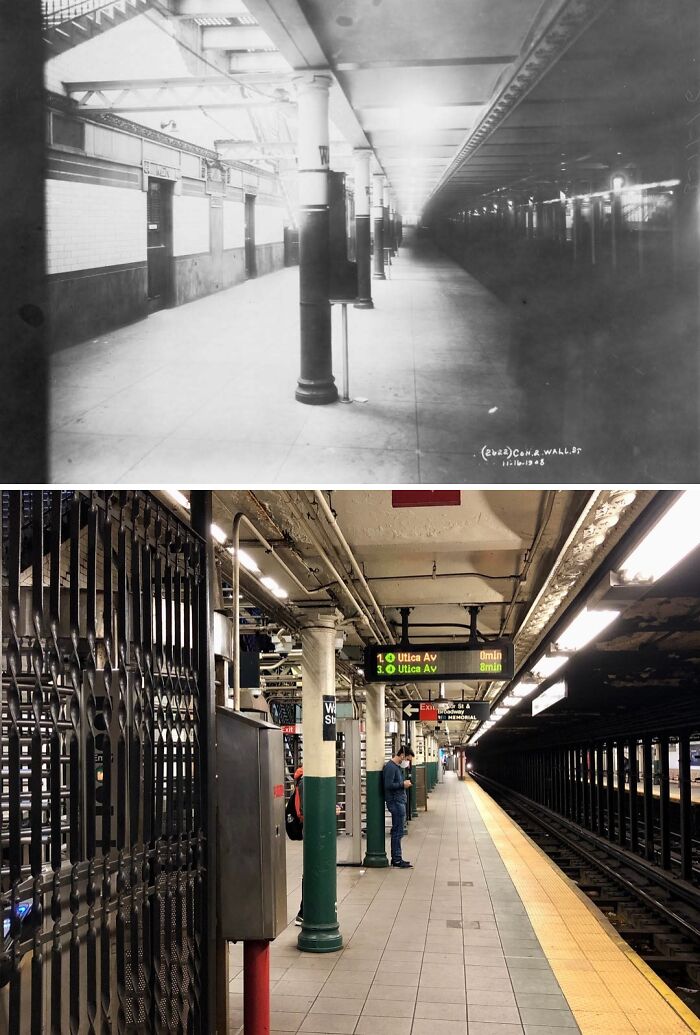
© Photo: nyc.beforeandafter
#67 Early 1900’s & Today
Looking south down Main Street from Northern Blvd in Flushing, Queens.
Virtually nothing seen in the 1900’s photo remains standing today. The sole exception is the spire of St. George’s Episcopal Church which can just be seen through the trees on the right-hand side. At the time that the old photo was taken, the entirety of Queens County boasted a population of about 153,000. As of the most recent census data, over 240,000 people live in just the Flushing, Murray Hill, and Whitestone areas alone and Queens is the city’s 2nd most-populated borough with over 2.3 million residents. Major contributing factors to Flushing’s rapid urbanization over the course of the 20th century were the opening of the Queensboro Bridge in 1909, the extension of the subway to the neighborhood in 1928 via the IRT Flushing Line (‘7’ line), the exodus of people from the inner-city to the suburbs following World War II, and the large influx of Asian immigrants to the area since the 1970’s.
Looking at Main Street today with all its hustle and bustle and constant stream of buses, it’s hard to believe that it was once just a lowly dirt road with a few-horse drawn carriages and a single trolley track. Had I taken the ‘after’ photo just a few years ago, the scene would’ve definitely looked even busier as Main Street used to be teeming with cars, vans, and trucks, prior to its conversion into a busway in 2021.
© Photo: nyc.beforeandafter
#68 1932 & Today
The NE corner of 8th Ave & 18th St in Chelsea, Manhattan.
.
Amazingly, despite the many changes that one might expect to have taken place in Manhattan over the course of 90 years, almost all of the buildings seen in the old photo still stand today. Of course, they might look a bit different, but they still stand nonetheless. Note how the corner building originally housed a restaurant in the 1932 image. Today, despite the hanging neon liquor sign, the building is occupied by a bakery.
© Photo: nyc.beforeandafter
#69 1919 & Today
Looking north at the intersection of Lexington Ave & E 56th St in Midtown East, Manhattan.
.
What was a tranquil residential neighborhood with townhomes intermixed with local shops has since been transformed into a bustling business center. In fact, there is only one survivor from the original photo; that being the building on the southwest corner of Lexington Avenue & 57th Street one block up the road. Even so, this area is still constantly changing as seen by the vacant lot on the left side of the present-day image. Also, note how much wider the sidewalks were before Lexington Avenue’s roadway was widened during the 1950’s.
© Photo: nyc.beforeandafter
#70 1904 & Today
Looking north along the southbound platform of the 59th Street-Columbus Circle station in Columbus Circle, Manhattan.
.
When the old photo was taken the 59th Street station had yet to be opened. 59th Street-Columbus Circle would be one of the original 28 stations to open on October 27, 1904, when New York City debuted its first subway line to the world. Like several of the 28 other stations, much of this station’s original design remains intact, albeit with a few modern touches here and there as seen in the present-day photo.
.
Take note of the lack of any turnstiles or full metal barriers in the old image. That is because upon its opening and prior to OMNY, the Metrocard, and even tokens, the subway system originally used paper tickets to collect fares. Passengers would descend into the station and walk up to the wooden booths seen in the background and purchase a paper ticket for 5 cents which would later be handed over to a clerk operating a ticket-chopper. To easily view an example of this method of fare collection today take a trip down to the Wall Street station on the (4,5) lines where an original wooden booth and ticket-chopper are still visible on the southbound platform.
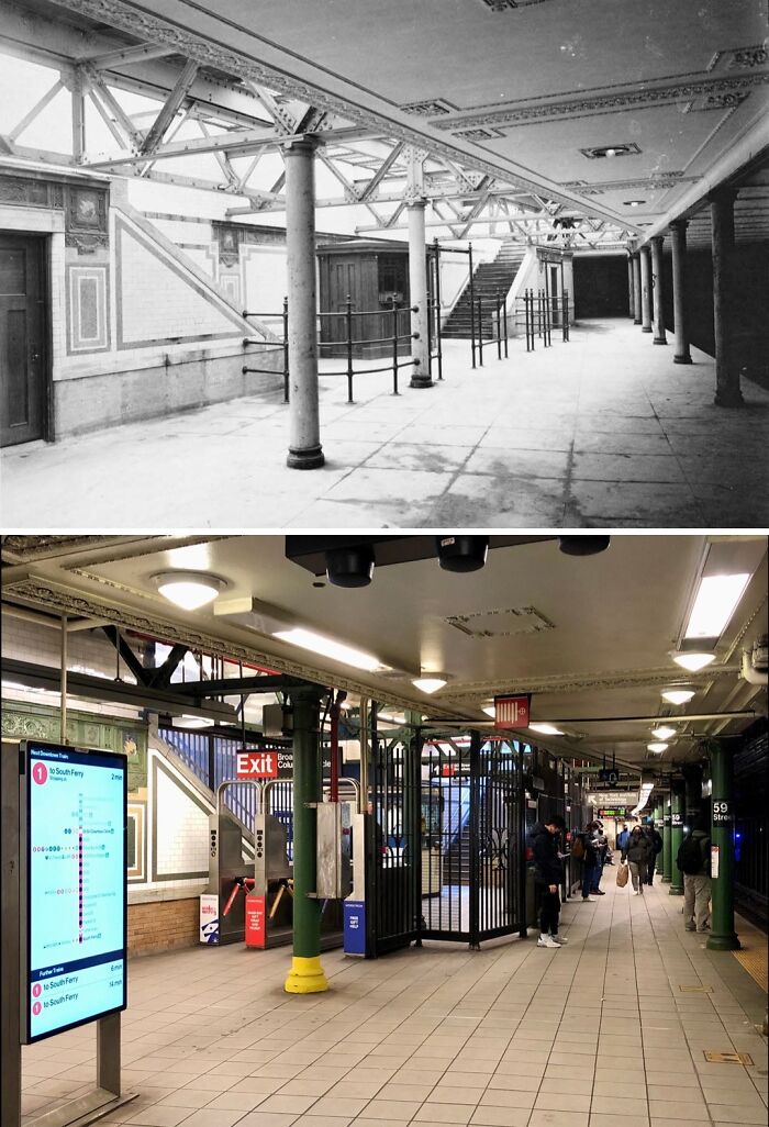
© Photo: nyc.beforeandafter
#71 1928 & Today
Looking north on Manhattan Ave from Huron St in Greenpoint, Brooklyn.
.
Though the exteriors of the buildings have changed a bit, for the most part, this view along Greenpoint’s main thoroughfare remains largely unchanged. Note the prices listed on the window of the store on the left that is today a laundromat. Salmon for 18 cents, cake flour sold at 2 for 25 cents, codfish 25 cents, and Wrigley’s chewing gum at 4 for 5 cents!
.
Also, is it just me or does the man standing beside the post in the old photo bear a striking resemblance to Alfred Hitchcock?
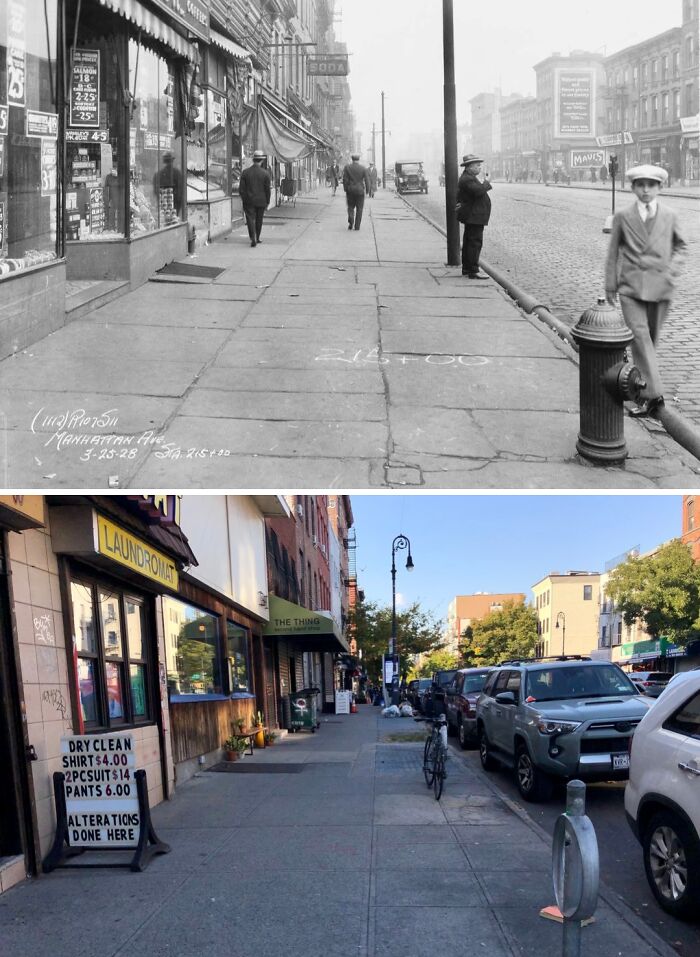
© Photo: nyc.beforeandafter
#72 1920 & Today
Looking north on Elton St from north of Hegeman Ave in East New York, Brooklyn.
.
Even as late as the 1920’s, New York City still featured some country-esque and semi-rural areas amidst the growing urban sprawl. East New York was one of these places. This would gradually change in the coming years as the city expanded outward and the subways spurred development farther out in the sticks. The land on the right is today the site of Elton Playground with an elevated section seen in the background connecting the New Lots Avenue station to the Livonia subway yard.
.
Sadly, I have no idea on who the two girls and boy in the old photo are but they appear to be pretty good friends (perhaps 2 of them are brother & sister?) and they seem to fairly elated at the fact they’re having their picture taken. They likely lived nearby and were hanging out when the photographer stopped by and couldn’t pass up the chance to be forever immortalized in film. If only they could’ve conceived that they’d one day up on the screen you’re viewing this post on right now. Again, it’s such a shame I don’t know their identities as nothing would please me more than to be be able to show any future descendants of theirs this photo. I sincerely hope these 3 amigos remained close long after their picture was taken and I hope they all lived long and prosperous lives. Rest in peace.
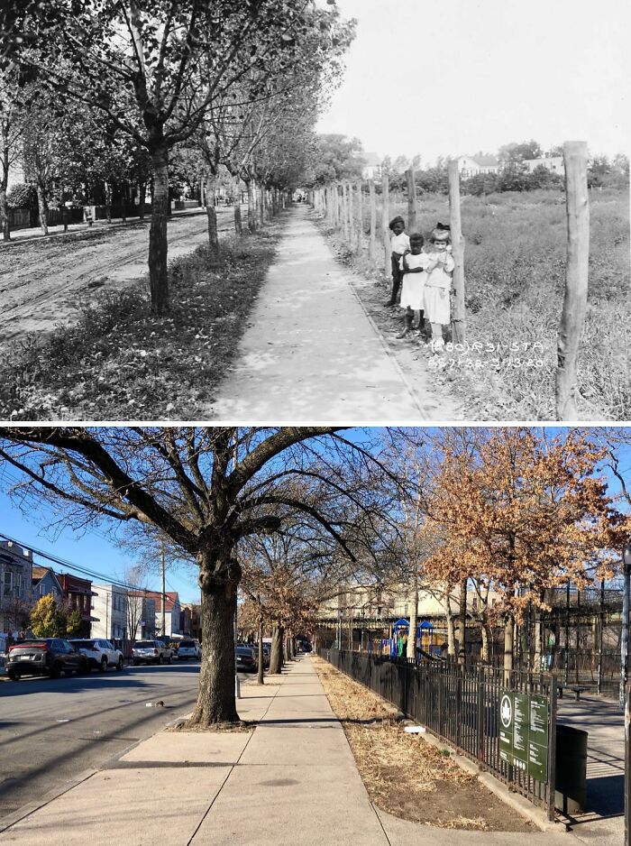
© Photo: nyc.beforeandafter
#73 1907 & Today
Looking north on Centre St from Grand St in Little Italy, Manhattan.
.
Still standing prominently on the right side of both photos is 240 Centre Street, better-known as Old Police Headquarters. Construction on the Beaux Arts-style building began in 1905 after the New York Police Department (NYPD) outgrew its previous headquarters as a result of the consolidation of the 5 boroughs in 1898 which saw a sharp increase in the size of police force . Upon its completion in 1909, the building served as the main headquarters of the NYPD until 1973 when the newer and larger 1 Police Plaza building opened farther downtown in the Civic Center. In 1988, the building was converted into luxury residences known as the Police Building Apartments. 240 Centre Street was designated a NYC landmark in 1978 and added to the National Register of Historic Places in 1980.
.
Lastly, note the hardware store on the corner in the old photo and the business advertising awnings and window shades in the background. As stated and seen in other posts, awnings were all the rage before the advent of air conditioning as the shade they provided on a building’s windows and doorways helped significantly in keeping interiors cool during the city’s hot summer months.
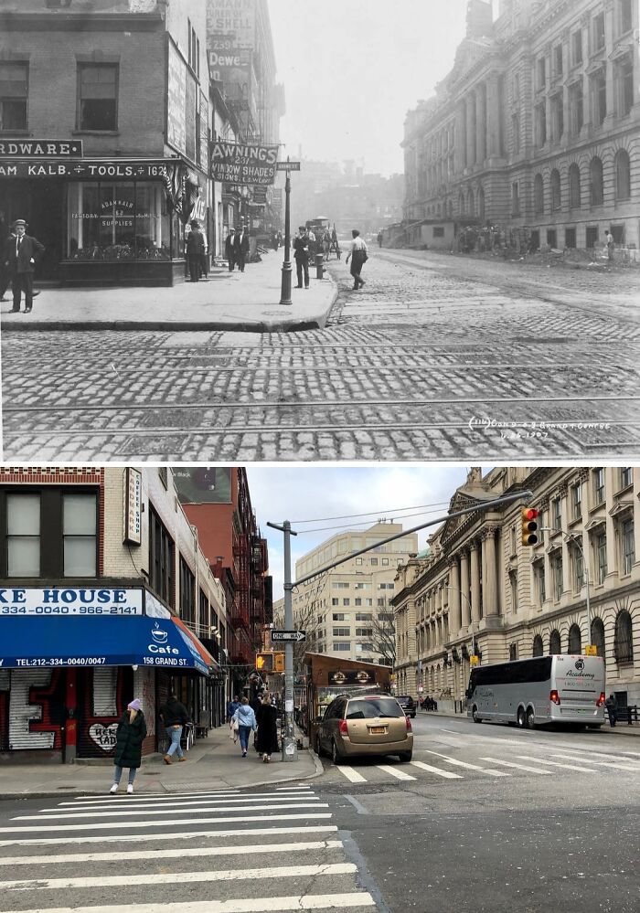
© Photo: nyc.beforeandafter
#74 1927 & Today
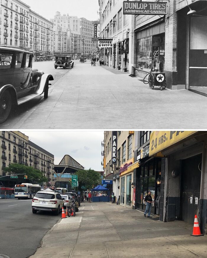
© Photo: nyc.beforeandafter
#75 1916
Looking north along Beach 36th St from Spray View Ave in Edgemere, Queens.
.
In the old photo are seen beautiful homes that once formed part of a thriving summer resort town known as Edgemere. The idea for a summer getaway from the hustle and bustle of New York City was the brainchild of Fredrick J. Lancaster, a land developer who saw potential in what had previously been just a sandy wasteland opposite the Atlantic Ocean on the Rockaway peninsula. The community, along with a nearby five story hotel known as the Edgemere Hotel, opened in 1895 and quickly became a popular summer getaway among New Yorkers. Edgemere was made readily accessible by the Long Island Rail Road’s Far Rockaway Branch which had a station at Beach 36th Street that also opened in 1895.
.
Edgemere would enjoy success for a couple of decades after its opening, though most of the homes seen in the old photo would be demolished in the 1920s and replaced by smaller rental units. Edgemere’s popularity would wane after World War II and many of the area’s summer bungalows were then converted into year-round homes and permanent residences. Then, in the 1960s, over 300 acres in the Rockaways, including much of Edgemere, were declared urban renewal areas by the city and were razed completely. However, anticipated development never came and huge swathes of land have remained barren for decades.
.
I do find it rather sad and ironic that what Lancaster once envisioned as thriving summer destination has now been reverted back to the exact state it was when he first laid eyes upon it; a desolate wasteland. Edgemere; a community buried beneath the sands of time.
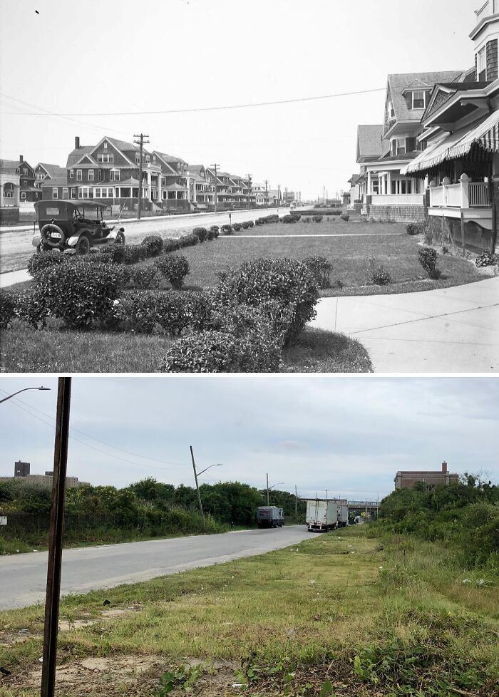
© Photo: nyc.beforeandafter
#76 1916 & Today
Looking west at E 14th St & 5th Ave in Union Square, Manhattan.
.
Even though many of the old buildings along 14th Street have been demolished over the decades, it’s nonetheless amazing to see that the two corner buildings on the west side of 5th Avenue are still standing. Note the huge banner on the building on the right. It reads: “We have disposed of our lease! Our entire stock of men’s and women’s new fall line of raincoats–overcoats–balmacaans to be sold retail at 50 cents on the dollar of regular wholesale price. Look at prices in windows!”
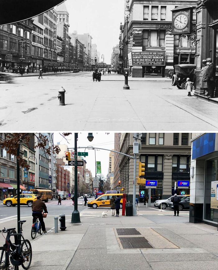
© Photo: nyc.beforeandafter
#77 1914 & Today
Looking west across 20th Ave from 86th St in Bensonhurst, Brooklyn.
.
The old photo was taken a couple of years prior to the construction and opening of the elevated BMT West End Line in this part of Brooklyn. Much of Bensonhurst had yet to be developed at this point as can be seen by the lack of buildings besides the one on the right that has survived into the present-day. Interestingly, the building appears to have been a library based on a partially obscured sign. A McDonald’s occupies the ground floor today.
.
Sadly, I have no idea who any of the people in the old photo are but they all seem to be amused by the presence of the photographer; still a rare sight back then. Lastly, note the little girl playing with a dog in front of the building’s entrance. One can only imagine how long she may have lived and what she may have experienced throughout her lifetime which so humbly began in a still semi-rural Brooklyn.
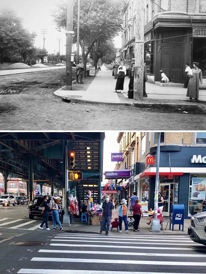
© Photo: nyc.beforeandafter
#78 1900 & Today
Looking south at the intersection of West 4th St & Cornelia St in the West Village, Manhattan.
.
Note how even at the dawn of the 20th century Manhattan still contained wood frame houses! The West Village was predominantly a working class neighborhood when the photo was taken, as can be seen by the overall streetscape and the clothing worn by the subjects. Also, take note of the vintage advertisements on the side of the corner building that once housed a carpenter shop. $6.50 for a suit!
.
No clue who the group of children or adults in the background are but they are most likely just kids and locals from the neighborhood excited and captivated by the presence of the photographer; a sight still not too common in those days. Nowadays, no one pays me any mind.
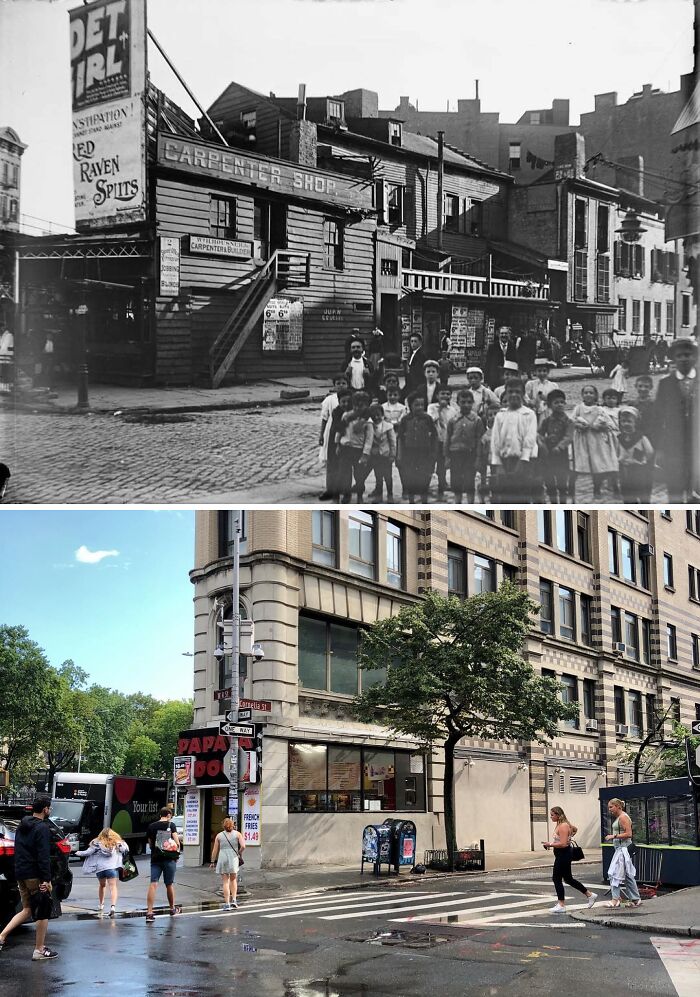
© Photo: nyc.beforeandafter
#79 1945 & Today
Looking south at Pell St & Doyers St in Chinatown, Manhattan.
.
What New York City student (or any student for that matter) doesn’t love a good ol’ field trip? The 1945 image shows an unidentified group of teenage girls touring around the heart of Manhattan’s Chinatown. Most appear to be intently listening to the tall man in the hat whose back is turned to the camera. I assume this was their teacher or guide of some sort. I wonder if any would end up buying souvenirs from Fung’s Gift Shop behind them.
.
Note, if any of these girls is still alive today they would be in their 90’s.
© Photo: nyc.beforeandafter
#80 1914 & Today
Looking north on the east side of New Utrecht Ave from 70th St in Bensonhurst, Brooklyn.
.
The old photo offers us an incredible view of New Utrecht Avenue prior to the construction of the elevated BMT West End Line in 1916. Beginning in 1863, Brooklyn, Bath and Coney Island Railroad originally ran trains down the middle of New Utrecht Ave (then known as Bath Plank Road) from 36th Street & 5th Ave in Sunset Park down to Coney Island-Stillwell Avenue. Once the El was built and completed in 1916, these surface-level tracks were retained for use by trolley lines until 1947 when the trolleys were placed by buses and the tracks were paved over. Today, the 71st Street station on the ‘D’ line sits above this spot.
.
The one thing in particular that drew my attention to the 1914 photo is the man and his dog just hanging out in front of what used to be a sort of grocery store. Note the signs advertising “poultry & game”, as well as ice, & coal. Judging by his attire, the man was most likely a grocer at said store. I’m no dog expert, but as a former owner of a Cocker Spaniel, I’d say that the dog in the photo appears to be part of the Spaniel family, though I can’t be certain. If anyone knows the exact breed of dog, feel free to leave it in the comments below!
.
I’ll admit that I was filled with some sadness at the realization that this man and his lovely faithful canine companion are long gone. I can only hope the dog enjoyed its time on Earth and that the man lived a good life. May they both rest in peace.
© Photo: nyc.beforeandafter
#81 1920s & Today
Looking north on Broadway from W 120th St in Morningside Heights, Manhattan.
.
It is nice to see that the scene remains practically unchanged since the 1920s save for the addition of a few buildings, the absence of the trolley and its tracks, and a different surface of roadway. The building seen on the left is the Union Theological Seminary while on the right is the Teachers College. The trolley in the old photo was part of the Third Avenue Railway’s Broadway Line. The line ran from 1884 until 1946 and is now the M104 bus route.
© Photo: nyc.beforeandafter
#82 1910 & Today
Looking south down Varick St from Laight St in Tribeca, Manhattan.
.
Nestled between the row of 19th century buildings at the center left of the old photo stood St. John’s Chapel. Originally built in 1803 by the renowned Trinity Church farther downtown, St. John’s was intended to serve Trinity’s growing Episcopal congregation. Designed by John McComb Jr., the designer of City Hall amongst other buildings, St. John’s was constructed in one of the most fashionable locations in New York at the time opposite the landscaped and tree-shaded St. John’s Park, also owned by Trinity Church. If you’re wondering why the park isn’t present in the old photo it’s because Trinity sold the park to Cornelius Vanderbilt in 1866 who used the land to build a freight depot for his New York Central Railroad.
.
By the 1890’s most of St. John’s congregation had left as part of the city elite’s move to uptown and so Trinity Church decided they wanted to sell the the chapel even against the wishes of a few devoted holdouts of St. John’s congregation, including the chapel’s pastor .1909 saw a vestry election take place at Trinity in which a pro-demolition faction rose to power. In 1912, plans were put forth by the city to widen Varick Street to facilitate construction of the IRT Seventh Avenue subway line which gave Trinity the excuse it wanted for the chapel’s sale and demolition. Despite public outcry from many New Yorkers, preservationists, architects, historians, and the Manhattan Borough President George McAneny, demolition of St. John’s went ahead in 1918. As for the railroad depot, it was razed in 1927 to make way for the Manhattan exit of the Holland Tunnel to New Jersey.
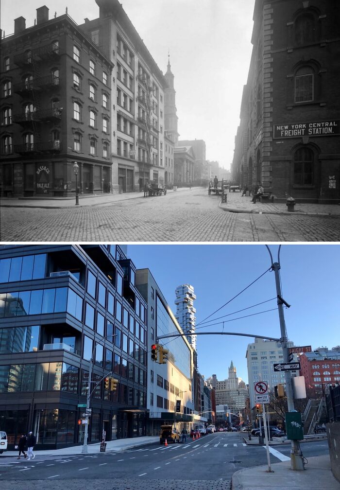
© Photo: nyc.beforeandafter
#83 1920 & Today
Looking west on E 14th St toward Avenue A in Alphabet City, Manhattan.
.
Alphabet City is part of the greater East Village and its name derives from the lettered avenues (Avenues A through D) that intersect the neighborhood; Manhattan’s only avenues to have single-letter names. The old photo shows a time when this area, as well most of the East Village, was still primarily a working class neighborhood as can be evidenced by the numerous tenements lining 14th St that were primarily occupied by European immigrants.
.
The row of buildings on the right were among hundreds demolished in the 1940’s to make way for the construction of the Stuyvesant Town-Peter Cooper Village, a private residential development. 18 city blocks consisting mostly of tenements were condemned under eminent domain and razed, displacing over 3,000 mostly low-income families. The controversy only continued once the development was completed, however, as minorities were barred from living in StuyTown for several years. Despite several failed lawsuits, strong community activism ultimately played a big role in leading to Metropolitan Life Insurance, the development’s owner, to repeal its discriminatory policies in the 1950’s.
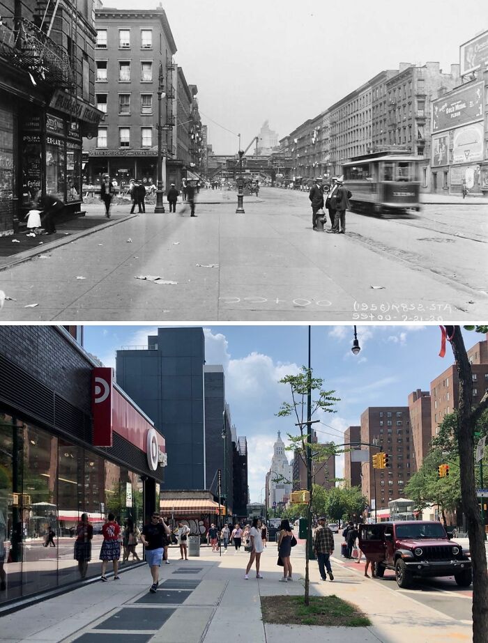
© Photo: nyc.beforeandafter
#84 1922 & Today
© Photo: nyc.beforeandafter
#85 1919 & Today
Looking north on Bushwick Ave from Powers St in East Williamsburg, Brooklyn.
.
The old photo was taken prior to the construction of the BMT Canarsie Line beneath Bushwick Ave. It is quite welcoming to see that practically all of the buildings from over 100 years ago remain today, albeit with a few alterations.
.
No idea who the 3 young girls are, though, curiously, it appears that the one on the far right appears to be crying. There also appear to be 2 pairs of legs obscured by the shop window beside her. Could someone have said a mean joke???
© Photo: nyc.beforeandafter
#86 1912 & Today
Looking north on Broadway from Prince St in SoHo, Manhattan.
.
Although some things have gone, like the lovely sidewalk clock in the old photo, overall, the changes in this post are minimal. As this area falls within the boundaries of the NYC-designated SoHo-Cast Iron Historic District, almost all of the buildings seen in the original photo have been preserved and are still standing today. Another thing that has certainly remained the same is SoHo’s role as a shopping district. Check out the old signs on the two buildings on the left advertising sweaters, suitcases, ladies’ hats, belts, and suspenders, among other things.
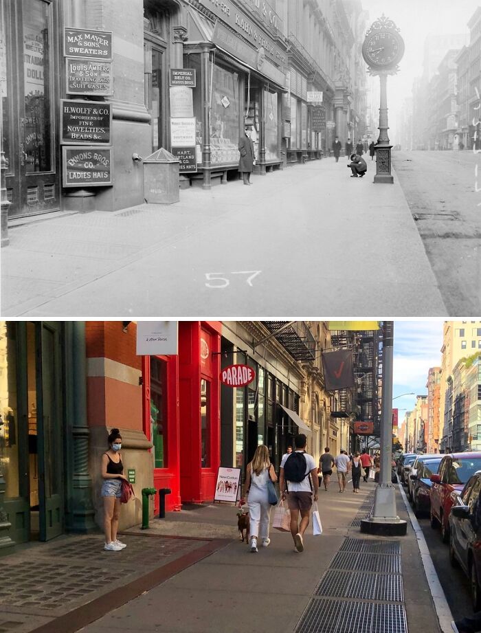
© Photo: nyc.beforeandafter
#87 1933 & Today
Looking south across Queens Blvd from 51st Ave in Elmhurst, Queens.
.
Although much has changed along this busy stretch of Queens Boulevard, one thing that has remained constant is the presence of the Elk Lodge building seen on the left side of both photos. Officially known as the Benevolent and Protective Order of Elks, Lodge Number 878, the Italian Renaissance-style building was completed in 1924 as a clubhouse for the Elks fraternal order at a cost of $750,000 (roughly about 11-12 million dollars today). Among the lodge’s numerous amenities were 28 guest suites, a gym, a swimming pool, a banquet hall, three bars, smoking rooms, a barber shop, bowling alleys, and a 700-seat Aztec-themed theater.
.
From the lodge’s inception in 1903 only White men could become members. In its heyday during the 1960’s, the lodge boasted over 6,600 members, including some of the borough’s most prominent politicians. Men of other races were allowed to join in 1973 and women members were only admitted in 1995. As the 20th century drew to a close, the lodge’s influence began to decline as many of the original members died or moved out of Queens, with the lodge losing 90% of its members between 1975 and 2001. Elmhurst’s demographics also changed around this time and these new residents showed little interest in the lodge.
.
In 2003, with roughly only 400 members left, the Elks sold the lodge building to the New Life Fellowship Church, a Korean church organization. The Elks still meet today in the building’s. The building was designated a NYC landmark in 2001 and added to the National Register of Historic Places in 2014.
© Photo: nyc.beforeandafter
#88 1909 & Today
Facing NW on Irving Pl toward E 18th St in Gramercy Park, Manhattan
.
Even after all the time that has passed, and despite undergoing several alterations, the buildings seen on both the corner in the foreground and in the background of both photos are still standing proud to this day. The same, however, cannot be said for the others as they were gradually demolished and replaced with larger apartment buildings as the neighborhood’s density increased in the years following the 1900’s.
© Photo: nyc.beforeandafter
#89 1946 & Today
Looking east on 9th Ave from College Point Blvd in College Point, Queens.
.
Apart from the evolution of the cars on the road and the lack of a lady sweeping, the scene along 9th Avenue remains largely unchanged nearly 80 years later. Do note, however, that even as late as the 1940’s certain parts of the city—especially in eastern Queens—still had dirt roads which must’ve been a pain to drive on when it rained. Also, the business seen on the far-left side in the old photo was once home to a tailor and furrier but today houses an electrical contractor.
© Photo: nyc.beforeandafter
#90 1918 & Today
Looking west on N 7th St toward Wythe Ave in Williamsburg, Brooklyn.
.
Despite many of the buildings seen in the old photo still standing today it is evident that ‘old vintage charm’ is no longer present, at least in this part of Williamsburg.
.
Of particular interest in the 1918 photo is the group of children hanging out in front of a store of some sort. I wonder if the photographer asked the girls on the right to pose or if they did so on the spur of the moment. Sadly, it appears that the boy behind the fire hydrant moved a bit during the photo-taking process and thus appears blurred. I cannot help but wonder what became of these children in later years and whether any of them have descendants still around today . In any case, I can only hope they all lived long and happy lives where they ended up. Rest in peace, children.
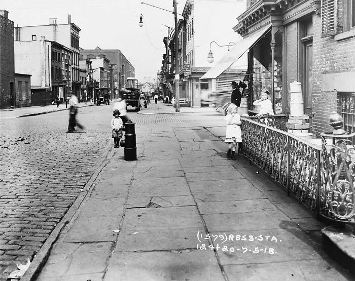
© Photo: nyc.beforeandafter
#91 1928 & Today
Looking north on Manhattan Ave toward Clay St in Greenpoint, Brooklyn.
.
A largely unchanged scene in Greenpoint is the subject of today’s post. The old cars, trolley, advertisements, and store signs, however, do lend a certain charm to the 1928 image. Also, note what appears to the lower half of a fire call box on the left, as indicated by the F.D.N.Y initials at the base. Today, a lamppost has taken its place, though judging by its appearance, the lamppost may have been installed not too long after the call box was removed.
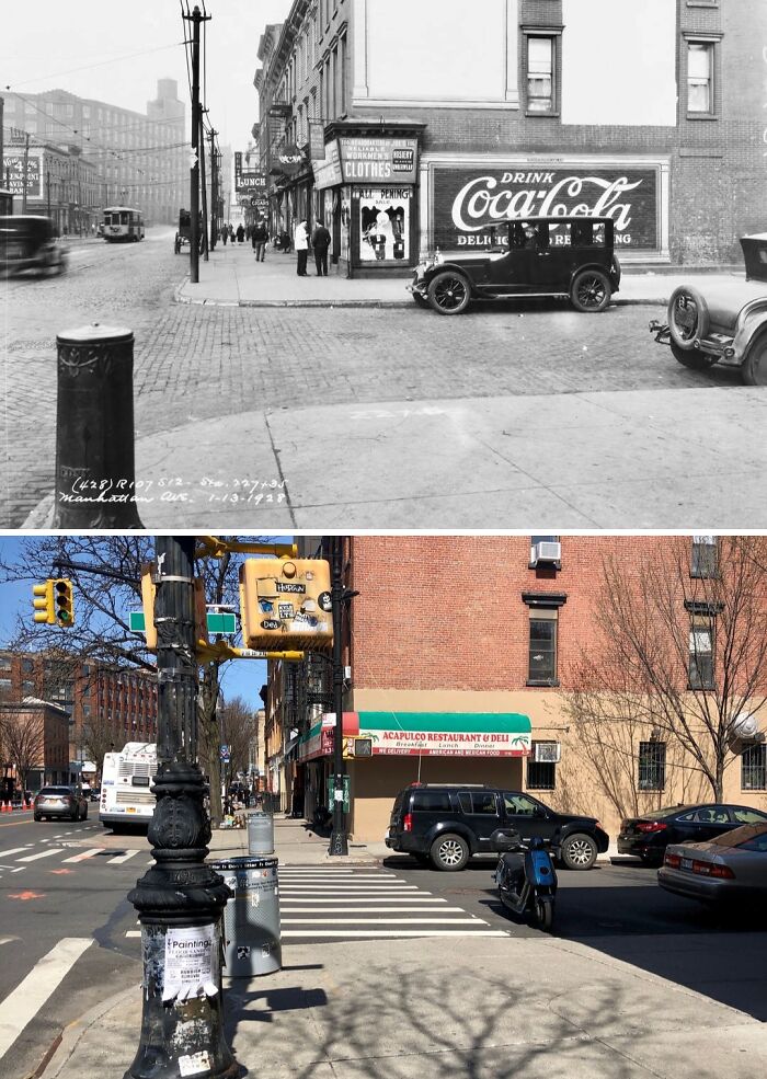
© Photo: nyc.beforeandafter
#92 1905 & Today
Looking east along the Rockaway Beach Boardwalk from B 102nd St in Seaside, Queens.
.
As seen by the old photo, dressing up in the early 20th century was not only the norm when out and about on the streets but also at the beach. Actually, in most places, there were strict sets of laws dictating what was and was not appropiate for men and women to wear on public beaches. Anyone deemed “indecently dressed” could expect to recieve a fine or even face arrest in some cases. As the 20th century progressed, laws concerning atire on beaches were gradually relaxed until being repealed or becoming flat out enenforced. So today, if you are plan on hitting the city’s beaches before the summer draws to a close, you need not worry about breaking any laws regarding what you wear. (Unless you’re naked, of course 🥴)
.
Also, take note of the wooden roller coaster that once extended out onto the sand. I actually struggled to dig up (pun not intended lol) much info regarding this coaster. According to an article in the Rockaways’ local paper, The Wave, the coaster was known as “The Thundertbolt Roller Coaster.” An aerial photograph from 1931 in the article shows that the coaster was still standing at that time. I also found a long legal document of what appears to have been a lawsuit in 1929 in which the operator of the ride was listed as the Thunderbolt Amusment Company. Apart from these sources, I found no further info regarding the coaster such as when it was built or when it was demolished. If anyone has any info regarding this mysterious roller coaster feel free to leave it in the comments section down below!
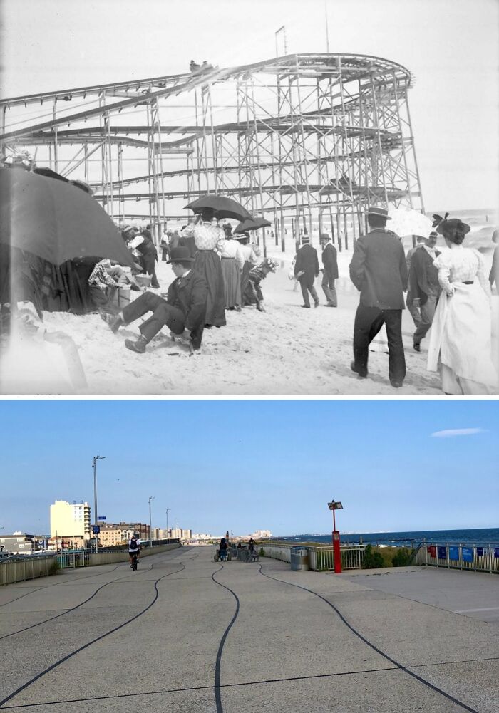
© Photo: nyc.beforeandafter
#93 1958 & today
Looking north toward the Lower Manhattan skyline from Governors Island, Manhattan.
.
It goes without saying that the Lower Manhattan skyline has evolved significantly over the years, but few realize by just how much. The 3 tallest buildings seen in the old photo on the right side of the image (from left to right: the Trump Building, the City Bank-Farmers Trust Building, and 70 Pine Street) are today obscured by newer buildings that sprang up closer to the shoreline during the 1960’s and 1970’s. Among the structures that remain visible today is the Battery Maritime Building with its 3 ferry slips. Today, it is the departure point for ferries from Manhattan to Governors Island.
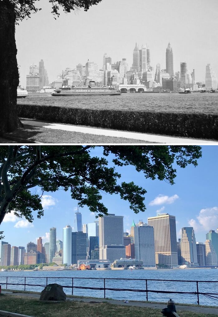
© Photo: nyc.beforeandafter
#94 1942 & Today
Looking north at the intersection of Sullivan Pl & McKeever Pl in Flatbush, Brooklyn.
.
The old photo appears to have been taken during the Brooklyn Dodgers’ home opener for the 1942 MLB season against the Philadelphia Phillies. You can see a banner above the ballpark’s main entrance that reads “Welcome Brooklyn Dodgers. National League Champions of 1941.” The Dodgers won the National League pennant the previous year against the St. Louis Cardinals but fell just short of their 1st World Series title against their crosstown rivals, the New York Yankees.
.
Ebbets Field opened in 1913 and was named after the Dodgers’ owner and president, Charles Ebbets, and would primarily serve as the home of Brooklyn’s pride and joy. After years of constantly falling at the last hurdle, the Dodgers finally won their first and only World Series in Brooklyn in 1955 when they beat the Yankees 4-3. After 65 years of disappointment, Brooklyn had finally won a championship! The euphoria would turn out to be short lived however when only 3 years later, Dodgers owner, Walter O’ Malley, would move the team to Los Angeles after plans to build a new stadium in Brooklyn fell through after an arduous dispute with city commissioner, Robert Moses, on where the stadium would be built. Brooklynites were left utterly heartbroken at the loss of their team; a team they had grown up watching, crying for, and cheering for, that was now gone forever. Ebbets Field would also meet the wrecking ball in 1960 and Ebbets Field Apartments, a privately owned apartment complex, was built on the stadium’s former site in 1962.
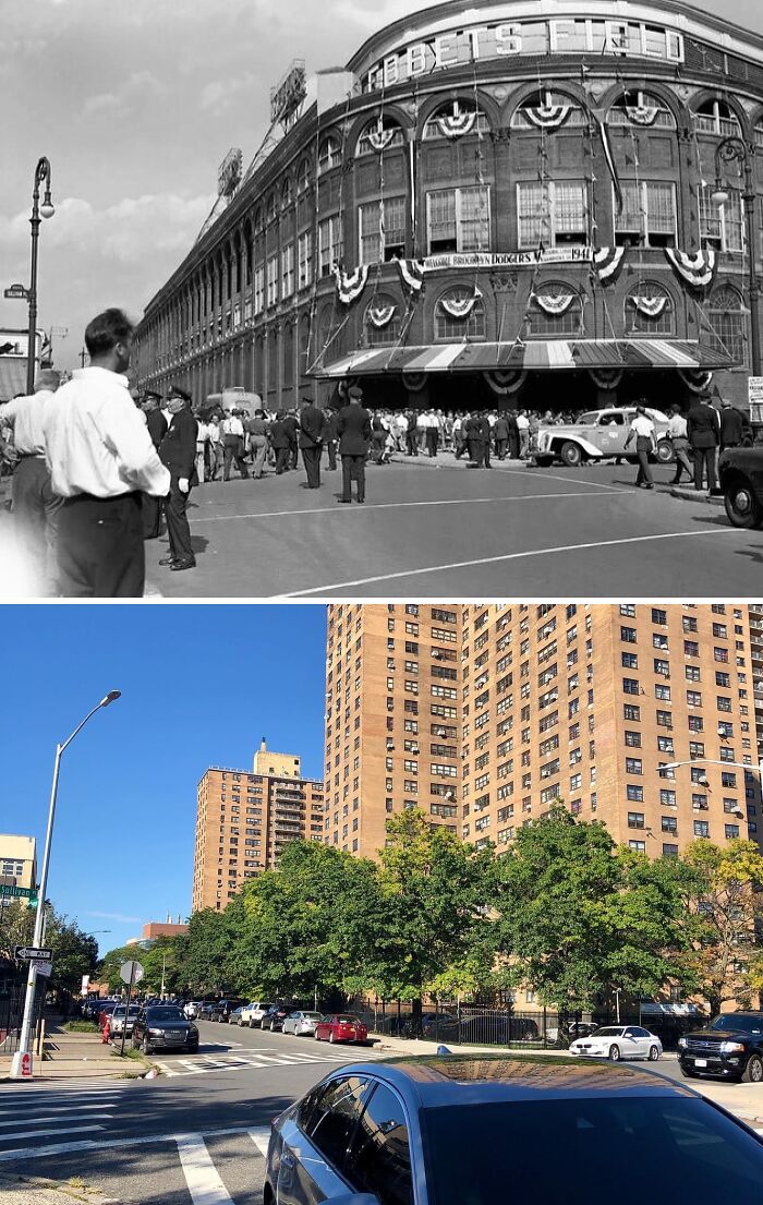
© Photo: nyc.beforeandafter
#95 1960 & Today
Looking north across Queens Blvd from 63rd Dr in Rego Park, Queens.
What is today the Rego Center with various different stores and businesses was originally home to one big anchor tenant: Alexander’s. Founded in 1928 by Brooklyn native George Farkas, the first Alexander’s store opened in the Bronx with the store being named after his father. Farkas intended the store to primarily cater to a middle-class clientele with designer clothes and other high-quality goods being sold at discounted prices. In spite of the Great Depression, two more stores were opened in the Bronx during the 1930’s as the chain steadily became a beloved and household name.
Since the mid-40’s, Farkas had wanted to build an Alexander’s in Rego Park and purchased the land where the store would eventually be built, but a dispute with the adjoining property owner & the city over the de-mapping of several streets impeded construction for nearly a decade. Ultimately, on Feb. 14, 1959, Alexander’s in Rego Park opened to huge fanfare. The store contained over 250,000 sq ft of retail space spread across 3 floors and a parking lot with room for over 2,000 cars. Throughout the 60’s and 70’s, the chain continued expanding with more locations opening in Queens & Manhattan, as well as on Long Island, Westchester, New Jersey & Connecticut. However, by the late 80’s, the stores were struggling to turn a profit as other chains began eating into their share of the market. Ultimately, in 1992, all Alexander’s stores were closed as the company filed for bankruptcy, resulting in the laying off of over 5,000 employees. Alexander’s would later be reorganized and today forms part of the Vornado Realty Trust.
© Photo: nyc.beforeandafter
#96 1929 & Today
Looking east on Broadway from 73rd St in Jackson Heights, Queens.
.
The only thing visible that remains from the old photo is the IRT Flushing Line’s elevated 74th Street-Broadway station which opened in 1917. What would become a bustling and diverse intersection in Jackson Heights still contained several vacant lots as late as the dawn of the 1930’s as seen in the old photo. The underground IND Queens Boulevard Line that was still 4 years away from opening would be instrumental in causing whatever available land there still was in the area to be developed.
© Photo: nyc.beforeandafter
#97 1942 & Today
Looking west on Queens Blvd toward 40th St in Sunnyside, Queens.
Over 80 years later, this view has remained largely unchanged. The only real change is the presence of several new buildings in the neighborhood, down the road in Long Island City and across the East River in Manhattan where the skyline has been significantly more-built-up since the 40’s.
The structure seen on the left is the elevated Queens Boulevard viaduct built in the 1910’s to carry the IRT Flushing Line (today’s ‘7’ line). The viaduct runs for just under a mile through the heart of bustling Sunnyside which was nothing but farmland and open fields when the line was being built. With ready access to Manhattan now available, it didn’t take long after the subway line’s opening for the neighborhood to develop.
© Photo: nyc.beforeandafter
#98 1907 & Today
Looking east up Mosco St toward Mott St in Chinatown, Manhattan.
.
Thankfully, all of the buildings seen in the old photo have survived into the present with only a few alterations! A welcome change from how most of the sites in my posts look like in the modern-era 😅 The stone church building on the left was built in 1801 as the Zion English Lutheran Church. It later became the Zion Protestant Episcopal Church before it was sold to Roman Catholic Archdiocese of New York in 1854 and became the Church of the Transfiguration, a name it has retained to this day. Originally the church served mostly local Italian and Irish immigrants but as the area’s demographics shifted over the decades, today its congregation is mainly Chinese. Sunday masses are offered in English, Mandarin, and Cantonese.
.
Note the Western Union office seen on the left side of the 1907 image. Where as nowadays we can instantly send a message to any place in the world instantly with a few taps on our smartphones, back then telegrams were still a major way in which messages were sent across long distances. This would soon change as the telephone became more common in households.
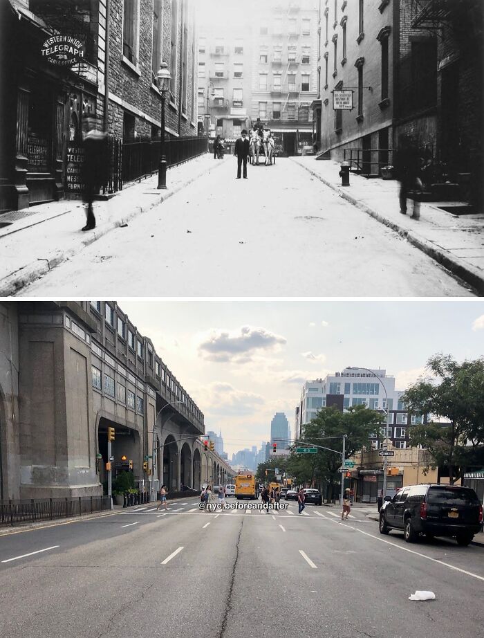
© Photo: nyc.beforeandafter
#99 1916 & Today
Facing the NW corner of 4th Ave & 77th St in Bay Ridge, Brooklyn.
.
The only thing that has remained relatively intact since the 1916 image is the entrance to the 77th Street subway station on the BMT Fourth Avenue Line (the ‘R’ train). Even so, the entrance has undergone some minor changes, most notable being the removal of the sign held up by two columns atop the stairway that read: “ENTRANCE TO MANHATTAN AND BAY RIDGE”. The silver-colored pillar with the blue “M” was likely installed in the late 60’s to early 90’s as the “M” was the logo of the New York City Transit Authority during that era. Personally, I don’t feel it fits with the style of the entrance or the rest of the street.
.
Speaking of the street, note how the lovely row of houses on the left are all sadly all gone today. The house closest to the camera was the first to go as it was demolished in the early 50’s to build the current church building which today is home to the United Korean Church of New York. The homes further up the block, meanwhile, were demolished sometime between 2006 and 2008 according to satellite images. The lots have remained empty for more than a decade at this point.
© Photo: nyc.beforeandafter
#100 1917 & Today
Looking east on W 57th St from 11th Ave in Hell’s Kitchen, Manhattan.
.
Nothing from the old photo remains today largely due to the thorough redevelopment this part of Hell’s Kitchen has gone through in over 100 years. The building seen on the right of the old photo that appeared to house something Chevrolet-related was demolished in the mid-1930’s and replaced with the existing building: the former Sheffield Farms Plant. At the time, Sheffield Farms was one of the largest dairy companies in the world and by some estimates over 20% of all milk purchased in New York came from Sheffield. In 1952, CBS purchased the building and today it is known as the CBS Broadcast Center; the network’s main production hub on the East Coast.
.
Also, take note of the street sweeper cleaning up the “residue” from a passing horse-drawn carriage. This goes to show that even as the 20’s approached and automobiles became more affordable to the masses, horses were still a vital mode of transporting people and goods throughout the city. And, of course, cleaning after them was vital to keeping the city clean.
© Photo: nyc.beforeandafter
from Bored Panda https://ift.tt/zcYb6l9
via IFTTT source site : boredpanda